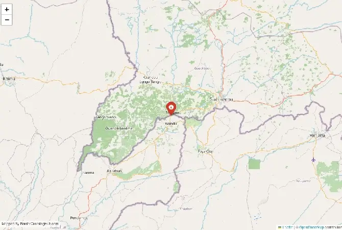
Monthly Update (September 2026):
Guéckédou region & Yenga remains a sensitive Guinea-Sierra Leone frontier area, but there has been a significant change since the previous closure period. Sierra Leone and Guinea officially reopened the Yenga/Koindu-Nongoa crossing on June 24 after it had been closed since April 2025, restoring cross-border movement and trade. The two governments also agreed that Guinea would give Sierra Leone at least 48 hours' notice before any future border closure. For September travelers, that makes the route more predictable than during the previous year, although local security and road conditions still warrant checking before departure.
About this crossing
Known as the Yenga Border or sometimes the Guéckédou Crossing, this route is far less predictable than other crossings between the two countries. It exists in a region where political history and local realities still shape how the border functions today.
A complicated historical background
Yenga became a focal point during the Sierra Leone civil war in the early 2000s. Guinean forces entered the village during the conflict, and control of the area has remained sensitive ever since.
Nearby Border Crossings




Although agreements have been reached at different times, the issue has never been fully resolved in a way that eliminates uncertainty on the ground. For you, this means that the border is not just a line on a map. It is a place where political decisions still influence daily operations.
This history also explains why the crossing never developed into a major transit point. Infrastructure remained limited, and administrative control can feel inconsistent compared to more stable borders.
What the crossing looks like in reality
You will not find a clearly defined checkpoint with structured lanes and signage. Instead, the crossing area is spread out, with administrative offices located in Guéckédou on the Guinean side and limited facilities near Yenga.
Guéckédou itself is a functioning regional town, with markets, transport links, and basic services. However, once you move closer to the border, things become less organized.
Yenga is a small settlement with minimal infrastructure. The border here feels more like a controlled zone than a formal crossing. You may not immediately know where to go, and asking locals or officials is often necessary.
Border procedures and how they work
You are still required to complete proper exit and entry procedures, but the process is not always straightforward. Typically, you will need to stamp out in Guéckédou before heading toward the Sierra Leonean side.
On arrival near Yenga, you will need to locate the appropriate officials for entry into Sierra Leone. Depending on the situation, this may involve traveling a bit further inland to complete formalities.
Visa requirements apply as usual. Guinea generally requires a visa in advance, while Sierra Leone offers visa-on-arrival for some nationalities, though you should confirm this before relying on it.
Processing times vary widely. On a good day, the process might take under an hour. On a difficult day, delays or even refusal to cross are possible.
Transport and access challenges
Reaching Guéckédou is manageable by regional standards. Roads connect it to Nzérékoré and other parts of southeastern Guinea, though conditions can vary.
Closer to the border, roads become more basic. Dirt tracks and uneven surfaces are common, especially as you approach Yenga.
Transport options are limited. Shared taxis operate between towns, but near the border you may need to rely on motorcycle taxis or local arrangements.
On the Sierra Leone side, roads lead toward Kailahun District. These routes are less developed, and transport can be irregular.
Planning your journey carefully is essential, especially if you intend to continue on the same day.
Seasonal effects on travel
Weather plays a major role here. The rainy season, typically from May to October, can make roads muddy and difficult to navigate. Some sections may become temporarily impassable.
During the dry season, travel is easier, but dust and heat become factors. Even then, road quality remains inconsistent.
Because infrastructure is limited, seasonal changes have a direct impact on how long your journey will take.
Safety concerns you should not ignore
This border is not considered highly dangerous in the same way as some Sahel مناطق, but it does carry more risk than typical Guinea–Sierra Leone crossings.
The unresolved status of Yenga means that security presence can vary. You may encounter checkpoints or restrictions that are not clearly explained.
Petty crime is also a possibility, particularly in less structured environments. The lack of clear procedures can create opportunities for unofficial payments or confusion.
You should stay alert, keep your documents secure, and avoid traveling alone if possible.
Checking current conditions before your trip is strongly recommended, as access can change depending on political developments.
Scams & Warnings
The main issues you are likely to face are minor but frustrating. Individuals may offer to guide you through the process or claim that additional steps are required.
These services are usually unnecessary. It is best to handle the process yourself unless you fully understand what is being offered.
If you are asked to pay a fee, ask for clarification or a receipt. This often reduces the likelihood of unofficial charges.
Currency exchange is limited and informal, so it is better to arrange money in advance.
Nearby areas and regional context
Guéckédou is the most important town in this area. It gained international attention during the Ebola outbreak and remains a key regional center.
While it does not attract many tourists, it provides essential services and a base for travel in southeastern Guinea.
Yenga, by contrast, is not a destination. Its significance comes entirely from its position on the border and its political history.
Most travelers who come here are either crossing for practical reasons or have a specific interest in border regions.
Cultural connections across the border
Despite the political complications, communities on both sides share strong cultural ties. Languages, traditions, and family connections extend across the border.
You will likely notice that local movement continues regardless of formal structures. People cross for trade, family visits, and daily الحياة, often in ways that reflect long-standing patterns.
This creates a contrast between official procedures and everyday reality.
Practical tips before you go
Preparation is essential for this crossing. Carry printed copies of your passport, visa, and vaccination records.
Bring enough cash in local currency, as there are no reliable banking facilities near the border.
Plan your transport carefully, including how you will continue your journey after crossing.
Travel during daylight hours only, and keep your belongings secure.
Remain flexible. If conditions are not suitable, you should be ready to change your plans.
Final thoughts
A crossing shaped more by history than convenience
The Guéckédou–Yenga border is not designed for easy travel. Its history, limited infrastructure, and uncertain status make it one of the more complex crossings in the region.
If you are well prepared and understand the risks, it is possible to pass through. However, for most travelers, more established crossings between Guinea and Sierra Leone offer a far more reliable option.
This is a border that reflects the realities of the region: shaped by history, influenced by politics, and requiring patience to navigate.
View all border crossings between Guinea and Sierra LeonePractical information
Fuel
Guinea: 2 km - Sierra Leone: 2 km
Currency
GNF,SLL informal
Safety information
Disputed area, checks
Connectivity
Limited 2G/3G mobile coverage
Have you crossed here?
Help other travelers by sharing your experience, wait times, and any updates.