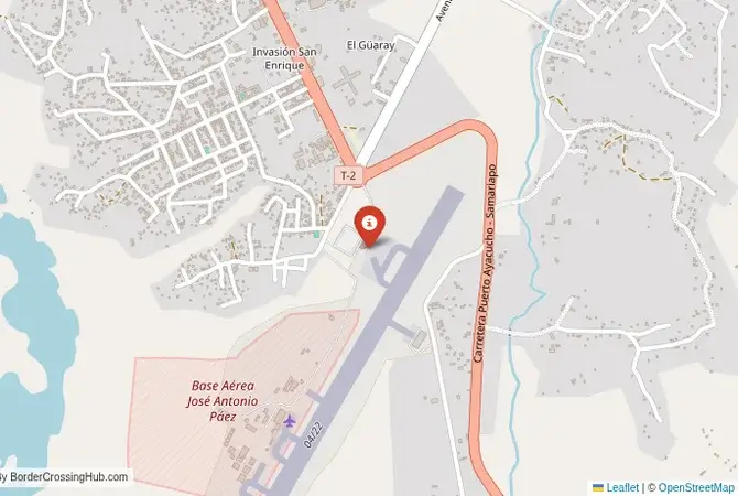
Monthly Update (October 2026):
Puerto Carreño & Puerto Ayacucho remains a much quieter and more logistically complicated border than the major road crossings farther west. Colombia's customs authority lists Puerto Carreño's international facility as a river port rather than a conventional road checkpoint, with weekday attention at the international dock. That makes timing particularly important for travelers using the Orinoco route, since there is no 24-hour land crossing here.
Driving there, or sending a driver? Send them this guide.
For reports and websites
Cite this page
Border Crossing Hub (2026). Puerto Ayacucho & Puerto Carreño Border Crossing. Updated October 2026. https://bordercrossinghub.com/puerto-carreno-puerto-ayacucho-border-crossing/<a href="https://bordercrossinghub.com/puerto-carreno-puerto-ayacucho-border-crossing/">Puerto Ayacucho & Puerto Carreño Border Crossing (Border Crossing Hub)</a>Put this crossing's card on your website
Free. It updates on its own when our information changes.
<iframe data-bch-card src="https://bordercrossinghub.com/puerto-carreno-puerto-ayacucho-border-crossing/?bch_view=card" width="100%" height="980" scrolling="no" style="border:0;max-width:480px;display:block" loading="lazy" title="Puerto Ayacucho & Puerto Carreño border crossing information"></iframe>
<p style="font-size:12px;margin:4px 0 0">Crossing information: <a href="https://bordercrossinghub.com/puerto-carreno-puerto-ayacucho-border-crossing/">Border Crossing Hub</a></p>
<script src="https://bordercrossinghub.com/?bch_embed_js=1" async></script>Paste it where you want the card. The last line (a script) only adjusts the height and can be left out.
About this crossing
Operational Details
This checkpoint connects the Vichada Department of Colombia with the Amazonas state of Venezuela. It is an international crossing, but its operation is dependent on the river transport services. Small boats (lanchas or bongos) constantly ferry people and goods across the Orinoco and Meta rivers between the two cities. There are formal immigration offices in both Puerto Carreño and Puerto Ayacucho where travelers must get their passports stamped. The crossing is a vital link for the local communities and for the limited trade that exists in this remote region.
A History of a Riverine Frontier
The history of this region is the history of the Orinoco River and the indigenous peoples who have inhabited its banks for millennia. The modern border was demarcated in the 20th century, but for the many indigenous groups in the region, the river has always been a unifier, not a divider. The cities of Puerto Carreño and Puerto Ayacucho grew up as river ports and administrative centers in the 20th century. The region has a complex security situation, with the historical presence of Colombian guerrilla groups and the recent rise of illegal mining and other criminal activities, particularly on the Venezuelan side.
Nearby Border Crossings
The Border Crossing Procedure
The border crossing procedure is a two-part process that requires navigating the river. You must first get your exit stamp from the immigration office (Migración Colombia in Puerto Carreño or SAIME in Puerto Ayacucho). You then hire a boat to take you across the river to the other city. Upon arrival, you must immediately go to the immigration office of the destination country to get your entry stamp. It is crucial to complete both steps. You will need a valid passport and any required visas. The atmosphere at the ports can be chaotic, so it is important to be vigilant.
The Surrounding Region: Colombia Side
On the Colombian side, Puerto Carreño is the capital of the vast and sparsely populated Vichada department. It is located at the confluence of the Meta and Orinoco rivers. The region is part of the Colombian Llanos, a vast tropical grassland. The main attraction is the stunning natural beauty and biodiversity of the region. The El Tuparro National Natural Park, a UNESCO biosphere reserve, is in this department, though it is very remote. The area is a paradise for sport fishing and birdwatching.
The Surrounding Region: Venezuela Side
On the Venezuelan side, Puerto Ayacucho is the capital of the Amazonas state. The city is known for the unique granite outcrops (lajas) that dot the landscape. The main attraction is the surrounding nature. The city is the gateway to the Venezuelan Amazon, a land of tepuis, rainforests, and numerous indigenous communities. However, the region has been devastated by illegal mining, and the security situation is extremely precarious. Travel in the Venezuelan Amazonas is extremely dangerous.
Practical Travel Information
Travel to this region is strongly discouraged. The security situation is extremely precarious. The official currencies are the Colombian Peso (COP) in Colombia and the Venezuelan Bolívar (VES) in Venezuela. Any travel must be undertaken with extreme caution and a deep understanding of the risks involved. This is a very remote region with limited infrastructure and a significant presence of illegal armed groups.
Final Considerations
The Puerto Carreño–Puerto Ayacucho border crossing is a journey into the wild heart of South America. It is a place where life is dictated by the great rivers. In normal times, it would be a gateway to a region of incredible natural beauty and cultural diversity. Today, it is a frontier that is defined by its remoteness and the complex security challenges that plague the region. It is a crossing for the most adventurous and well-informed of travelers, a passage on the mighty Orinoco that is as beautiful as it is challenging.
View all border crossings between Colombia and VenezuelaHeading to Puerto Ayacucho & Puerto Carreño? Take this with you.
One page with the hours, waits, emergency numbers and coordinates. Works without signal.
Practical information
Fuel
Colombia: 2 km - Venezuela: 2 km
Currency
Limited near Puerto Carreño (COP, VES)
Safety information
Remote, river hazards
Connectivity
Basic 3G coverage
Have you crossed here?
Help other travelers by sharing your experience, wait times, and any updates.