Monthly Update (September 2026):
Ammer Saddle & Ettal remains a scenic mountain route between Austria and Bavaria, with no major September border disruption reported. Germany's temporary controls on the Austrian frontier remain in force through September 15, so travelers should keep their identification accessible. With summer tourism beginning to ease, road traffic should generally be more manageable than during the peak August period.
About this crossing
Location and Connections
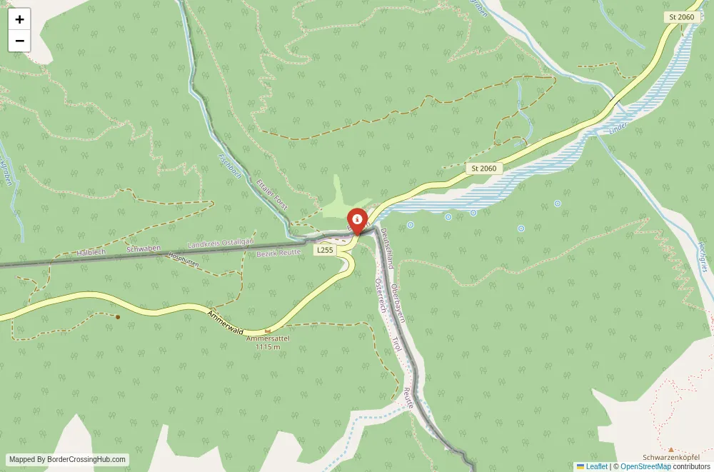
You find this pass at 1,082 meters where the German state of Bavaria borders Tyrol in Austria. The road starts from Ettal (near Oberammergau) on the B23, ascends past Linderhof Palace, crosses the saddle, and descends toward Plansee and Reutte in Austria. From Ettal, the border lies about 15 to 20 minutes drive south. On the Austrian side, Plansee sits a short distance away, with Reutte roughly 20 to 30 minutes further. Cars, motorcycles, buses, and cyclists use it most; trucks avoid the narrower sections. The route connects the Ammergau Alps region to the Lechtal valley, popular for those heading from Garmisch-Partenkirchen or Oberammergau toward Füssen, Innsbruck, or avoiding major highways.
Alternative Names
It appears as Ammer Saddle, Ammersattel, or sometimes Planseestraße (after the road segment near Plansee). The crossing is often called Ammersattel Grenzübergang or the Ettal-Reutte pass.
Nearby Border Crossings




Historical Background
The pass developed in the 19th century under Bavarian King Maximilian II, with the road built around 1852 to improve access through the Graswang Valley. It served trade and travel between Bavaria and Tyrol amid alpine border adjustments. During the Cold War era, the Austria-Germany border stayed open but with customs formalities until Schengen in 1997-1998 (full implementation for land borders). The route ties into Ludwig II's era, passing near Linderhof Palace and Ettal Abbey, both royal foundations. Today the saddle remains a quiet link, with no major changes from Schengen.
Geopolitical Context
As part of Schengen since the late 1990s, the crossing normally has no routine passport or customs checks for EU citizens or visa-exempt travelers. Germany and Austria occasionally introduce temporary controls for security or migration, but as of February 10, 2026, no widespread land border restrictions apply between them (unlike some eastern borders). Spot checks can occur randomly, especially during peak seasons or events. The border follows natural features in the Ammergau Alps, with the saddle itself lying very close to the line (some maps place the high point slightly on Austrian soil). Confirm current status via official police or foreign ministry sites if concerns arise.
Practical Crossing Procedures
You drive straight across with a border marker or sign indicating the shift. No booths or queues normally exist. In rare temporary checks, police may stop you for ID verification or basic questions. EU citizens show passport or national ID. Non-EU nationals carry valid passports, visas/residence permits if required, and proof of onward travel or funds. Vehicles need valid insurance; Austria requires a vignette for motorways (but this road avoids them, so no vignette needed here). Pedestrians and cyclists cross too, though the road sees mostly vehicles.
Typical Wait Times
You usually cross in seconds with no holdup. Any spot checks add 5 to 20 minutes at most, depending on questions. Traffic stays light compared to Fernpass or Brenner, so even summer weekends rarely cause backups beyond brief pauses.
Operating Hours
The road operates 24/7 year-round. No fixed closures apply since Schengen. Winter snow or ice can limit access temporarily, but plowing keeps it open most times.
Transportation Options and Road Conditions
Drive your own car or motorcycle for the best experience; regional buses connect Ettal to Reutte via this route in season. The B23/B179 offers a well-paved, two-lane mountain road with steady climbs (up to 12% gradients in places), tight curves, and elevation changes. Pavement quality holds strong, but watch for cyclists, wildlife, or falling rocks in forested sections. Scenery includes alpine meadows, dense woods, the Graswang Valley, and views toward Plansee lake on the descent.
Scams & Warnings
This quiet alpine pass has few reported scams. No common touts or fake services exist. Informal parking or roadside vendors near attractions like Linderhof occasionally overcharge, but issues stay minor. Keep valuables secure in cars at pullouts. Mountain driving requires caution: steep drops, fog, or sudden weather shifts occur. The area feels safe overall for alert travelers.
Nearby Attractions
Ettal boasts the impressive Baroque Ettal Abbey with its domed church and monastery brewery. Linderhof Palace (nearby on the German approach) offers ornate rooms and gardens from Ludwig II's era. Plansee provides a rugged alpine lake with boating or walks. Reutte leads to Füssen with Neuschwanstein and Hohenschwangau castles. The Ammergau Alps Nature Park surrounds it with hiking trails, cross-border paths, and winter skiing options.
Seasonal Variations and Weather Impacts
Winter snow from December to March demands winter tires or chains; roads ice easily at altitude. Summer draws tourists and motorcyclists with clear views. Autumn foliage colors the valleys vividly with lighter traffic. Rain or fog reduces visibility on curves, but full closures remain unusual unless extreme.
Travel Tips and Preparation
Carry passport or ID for any spot checks. Pack water and snacks for remote stretches. Check weather forecasts for mountain conditions. Drive defensively on curves and gradients. If hiking nearby, use marked trails in the national park areas. Refuel in Ettal or Reutte, as services thin out at the saddle.
Cultural and Economic Significance
The crossing supports tourism in the Ammergau Alps and Lechtal, linking royal sites, abbeys, and lakes that draw visitors year-round. Local economies benefit from cross-border day trips, with shared alpine heritage in hiking, skiing, and historical routes. It remains a peaceful artery amid busier alpine passes.
Before You Cross
Double-check road and weather conditions from official sources before departure. With basic prep for mountain driving and awareness of rare checks, you enjoy this scenic saddle crossing and continue through the Alps' stunning valleys. Safe travels.
View all border crossings between Austria and GermanyPractical information
Fuel
Austria: 20 km - Germany: 19 km
Currency
EUR only; ATMs in Ettal/Grainau
Safety information
Mountain driving risk; snow restrictions possible
Connectivity
Wi-Fi points; 4G
Have you crossed here?
Help other travelers by sharing your experience, wait times, and any updates.