Monthly Update (September 2026):
Tilali & Puerto Acosta remains a very lightly used Peru-Bolivia crossing, with no significant September closure or reopening identified. Peru's Migraciones continues to list Tilali among its authorized border-control posts, alongside Carancas and the much busier Desaguadero and Kasani crossings. The crossing remains a poor choice for travelers expecting a major international border facility, as the route has historically had limited infrastructure and very little regular traffic.
Driving there, or sending a driver? Send them this guide.
For reports and websites
Cite this page
Border Crossing Hub (2026). Tilali & Puerto Acosta Border Crossing. Updated September 2026. https://bordercrossinghub.com/tilali-puerto-acosta-border-crossing/<a href="https://bordercrossinghub.com/tilali-puerto-acosta-border-crossing/">Tilali & Puerto Acosta Border Crossing (Border Crossing Hub)</a>Put this crossing's card on your website
Free. It updates on its own when our information changes.
<iframe data-bch-card src="https://bordercrossinghub.com/tilali-puerto-acosta-border-crossing/?bch_view=card" width="100%" height="980" scrolling="no" style="border:0;max-width:480px;display:block" loading="lazy" title="Tilali & Puerto Acosta border crossing information"></iframe>
<p style="font-size:12px;margin:4px 0 0">Crossing information: <a href="https://bordercrossinghub.com/tilali-puerto-acosta-border-crossing/">Border Crossing Hub</a></p>
<script src="https://bordercrossinghub.com/?bch_embed_js=1" async></script>Paste it where you want the card. The last line (a script) only adjusts the height and can be left out.
About this crossing
Location and Basic Connections
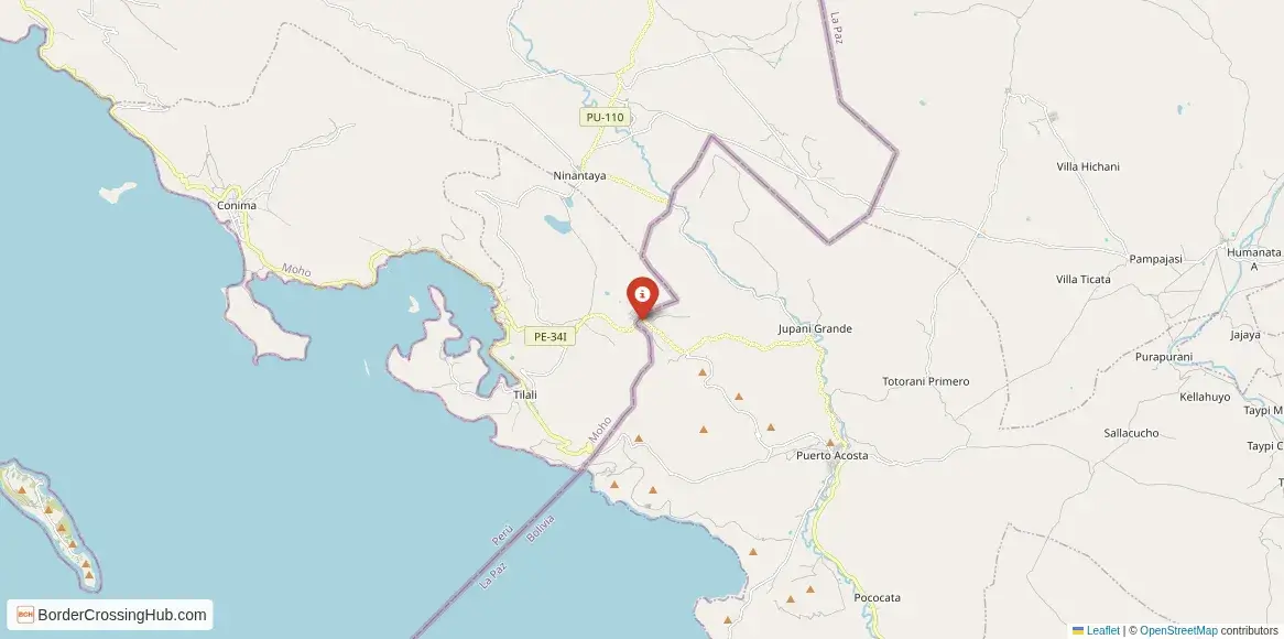
You arrive at this remote spot on dirt roads that trace the lake's northern coastline. Tilali rests in Peru at roughly 3800 meters elevation, reached from places like Juliaca or Moho over several hours of unpaved travel. Puerto Acosta sits on the Bolivian bank, with local routes leading to Copacabana, Escoma, or La Paz. The border involves crossing a short stretch of no man's land, sometimes just a few kilometers by foot or vehicle. Shared taxis, minibuses, or bicycles serve the Peruvian approach from Moho or Huancané, while Bolivian transport connects from Copacabana or nearby villages. This route draws few international tourists, mostly independent cyclists, overlanders, or locals who prefer it over the busier Desaguadero or Kasani points.
Alternative Names
People refer to it as Paso Tilali Puerto Acosta, Tilali border post, Puerto Acosta crossing, or the northern Lake Titicaca frontier point.
Nearby Border Crossings



Historical Background
The lake shores here have been shared by Aymara communities for centuries, long before formal national boundaries. The current line stems from 19th and early 20th century agreements following independence and border disputes. Tilali grew as a small rural district focused on fishing and farming, while Puerto Acosta developed around lake trade and transport. Peru established a formal migration office in Tilali around 2017 to manage increasing overland movement, including routes like the Ruta de las Tres Cordilleras. For years the area functioned informally, sometimes described as a secondary path used by locals and occasional smugglers due to limited patrols.
Geopolitical Significance
This crossing provides an alternative to the main Titicaca passages, useful for those exploring northern lake routes or avoiding crowds. It supports everyday Aymara family and trade links in border zones under binational neighborhood agreements. Traffic remains light compared to Desaguadero, focusing on residents rather than heavy commerce. As of early 2026 the post operates without widespread reports of closure, though its isolated nature means occasional staffing gaps or weather-related interruptions. Verify current conditions through Peruvian Migraciones or Bolivian migration offices before heading out.
Practical Crossing Procedures
You start on the Peruvian side at Tilali's migration building for exit stamps, luggage checks, and basic customs if carrying goods. Then proceed across the dirt track to Puerto Acosta for Bolivian entry processing, including passport stamps and possible bag inspection. Most nationalities receive visa-free entry for tourism stays of 90 days in each country. Carry your passport valid for at least six months, proof of onward travel if requested, and small cash. Some sections require walking between posts, especially if transport drops you short. Declare any items over personal limits; fresh produce or animal products often face restrictions. The process suits pedestrians, cyclists, or light vehicles in this basic setup.
Typical Wait Times and Operating Hours
Hours roughly follow daylight, typically 0800 to 1800 or 2000, though exact times fluctuate with staffing. Due to low volume, waits rarely exceed 15 to 45 minutes total for both sides. No long lines form here, unlike larger crossings, but inconsistent presence can cause brief delays.
Transportation Options
Shared taxis or colectivos run from Juliaca, Moho, or Huancané to Tilali, then local rides or walking bridge the border gap. On the Bolivian side, minibuses or taxis connect Puerto Acosta to Copacabana and beyond. Cyclists and motorbikes navigate the route regularly. Private vehicles manage the dirt roads, though high clearance helps on rough sections. Hitchhiking works among locals, but plan connections carefully in this sparse area.
Road Conditions and Scenery
Unpaved tracks dominate, with loose gravel, ruts, and steep lake-edge drops. Rain creates mud and puddles, while dry periods leave dust. The scenery features expansive Titicaca waters, reed boats, terraced fields climbing hillsides, and distant Andean peaks. Vicuñas, llamas, or lake birds appear along the way. The high altitude brings thin air, strong sun, and cold winds.
Scams & Warnings
This quiet crossing has minimal tout activity, but occasional informal helpers may ask for fees to assist with paperwork; decline and use official counters. Exchange rates at the border favor locals; change money in towns. Altitude sickness strikes fast above 3800 meters; acclimate properly, drink water, and carry medication. Carry extra food, water, and layers, as services are scarce. Walking long distances between posts requires caution on empty roads. Recent traveler notes mention occasional unofficial charges or inconsistent staffing. Check forums or migration sites for the latest.
Nearby Attractions
Tilali provides peaceful lake views, small Aymara villages, and a sense of rural highland life. Puerto Acosta offers fresh trout markets, basic eateries, and access to northern Titicaca shores for boat rides or fishing. Copacabana (Bolivia) lies a few hours away with its famous basilica and Isla del Sol. On the Peruvian side, Juliaca or Puno provide larger markets, Uros islands, and Sillustani ruins. The route appeals to those seeking off-main-path Titicaca exploration.
Seasonal Variations and Delays
Dry season from May to October delivers firmer roads and clearer weather. Rainy months from November to April turn tracks slippery or flooded, causing delays or temporary inaccessibility. Cold nights and frost persist year-round at this elevation. Low traffic reduces crowd-related waits, but weather remains the main variable.
Cultural and Economic Role
Cross-border movement keeps family networks and small trade alive, with lake fish, produce, and handicrafts moving both ways. Aymara traditions dominate on both sides, reflected in daily life, textiles, and shared festivals. The crossing highlights rural Andean connections beyond tourism hubs.
Final Planning Notes
Travel during daylight hours and carry passport copies, small bills in PEN, BOB, or USD, snacks, water, and warm clothing. Confirm status through official migration channels or recent traveler reports. This suits self-reliant explorers comfortable with basic, remote conditions and high altitude. Prepare for potential walking and rough access.
Managing This Northern Titicaca Passage
Tilali Puerto Acosta gives you a simple, scenic border experience along Lake Titicaca's quieter northern shore, away from main tourist flows. With proper preparation, altitude awareness, and flexibility, you complete this Andean frontier hop as part of authentic altiplano travel.
View all border crossings between Peru and BoliviaHeading to Tilali & Puerto Acosta? Take this with you.
One page with the hours, waits, emergency numbers and coordinates. Works without signal.
Practical information
Fuel
Peru: <1 km - Bolivia: <1 km
Currency
S/; Bs in Puerto Acosta; cash only common
Safety information
Remote; limited fuel/aid; avoid late travel
Connectivity
Wi-Fi points; 4G
Have you crossed here?
Help other travelers by sharing your experience, wait times, and any updates.