Monthly Update (September 2026):
Tambo Quemado & Chungará remains the main Bolivia-Chile road route across the high Andes, with heavy freight traffic continuing to distinguish it from the quieter alternatives. BCH's current page lists the crossing as operating around the clock, with passenger waits generally shorter than truck queues. September is still part of the winter period at more than 4,600 metres, so snow, ice and strong winds remain the main risks to an otherwise open crossing.
Driving there, or sending a driver? Send them this guide.
For reports and websites
Cite this page
Border Crossing Hub (2026). Tambo Quemado & Chungará Border Crossing. Updated September 2026. https://bordercrossinghub.com/tambo-quemado-chungara-border-crossing/<a href="https://bordercrossinghub.com/tambo-quemado-chungara-border-crossing/">Tambo Quemado & Chungará Border Crossing (Border Crossing Hub)</a>Put this crossing's card on your website
Free. It updates on its own when our information changes.
<iframe data-bch-card src="https://bordercrossinghub.com/tambo-quemado-chungara-border-crossing/?bch_view=card" width="100%" height="980" scrolling="no" style="border:0;max-width:480px;display:block" loading="lazy" title="Tambo Quemado & Chungará border crossing information"></iframe>
<p style="font-size:12px;margin:4px 0 0">Crossing information: <a href="https://bordercrossinghub.com/tambo-quemado-chungara-border-crossing/">Border Crossing Hub</a></p>
<script src="https://bordercrossinghub.com/?bch_embed_js=1" async></script>Paste it where you want the card. The last line (a script) only adjusts the height and can be left out.
About this crossing
Location and Basic Connections
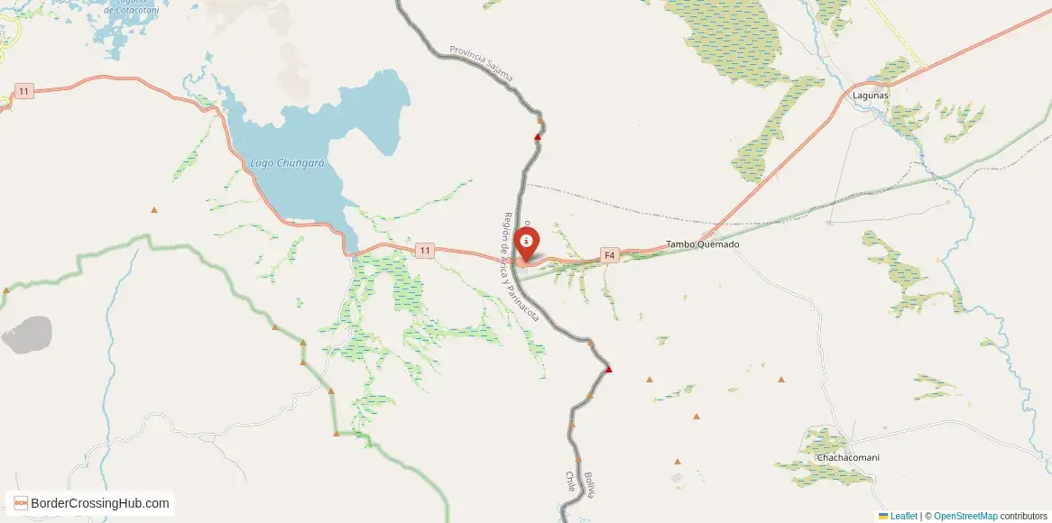
You approach this high-altitude pass along Ruta Nacional 4 on the Bolivian side from La Paz or Oruro, and Carretera Internacional CH-11 on the Chilean side from Arica or Putre. The Bolivian post sits at Tambo Quemado, while the Chilean complex is at Chungará, separated by about 7 to 20 km of no-man's-land road. Buses from La Paz to Arica or vice versa use this route regularly, often with stops for formalities. Private vehicles or shared taxis cover the stretches from major towns. The crossing handles significant truck traffic for trade, alongside tourists heading between the altiplano and northern Chile.
Alternative Names
This point goes by Chungará-Tambo Quemado, Paso Chungará, Paso Tambo Quemado, or the Chungará border complex.
Nearby Border Crossings



Historical Background
The pass follows the Cordillera Occidental of the Andes, shaped by early 20th-century boundary agreements between Bolivia and Chile. It gained importance as a trade corridor after Bolivia lost coastal access in the 19th century, providing the shortest land link to the sea at Arica. Infrastructure improvements, including paving, came in later decades to support growing freight. The area features stunning natural surroundings, with Lake Chungará nearby on the Chilean side, part of Lauca National Park.
Geopolitical Significance
This crossing plays a central role in Bolivia's access to Pacific ports and Chile's connections to the altiplano. It supports bilateral trade in minerals, agricultural goods, and consumer products. Joint efforts between the countries, including recent training on migration and crime prevention in 2025, aim to streamline operations. As of early 2026, the crossing operates continuously 24 hours for vehicles since mid-2024 expansions, though weather can force temporary closures. Check official sources from Chilean Pasos Fronterizos or Bolivian customs for updates, especially during winter snows.
Practical Crossing Procedures
You handle two separate checkpoints: first one country's immigration and customs, then drive the intervening road, then the second. From Bolivia to Chile, exit at Tambo Quemado (Bolivian side), cross the pass area, then enter at Chungará (Chilean side). Processes involve passport stamps, vehicle inspections, and customs declarations. Chile requires temporary vehicle import papers, insurance proof, and often a disinfection certificate. Bolivia may check for export restrictions on certain items. Most nationalities enter visa-free for tourism (90 days in Chile, similar in Bolivia). Bring your passport valid for six months, vehicle registration, and cash for any minor fees. Everyone must disembark for checks; expect thorough scans.
Typical Wait Times and Operating Hours
The crossing runs 24/7 for freight and vehicles as of recent updates, though passenger processing aligns with daylight or demand in practice. Waits vary: quick crossings take 30 minutes per side, but truck queues or peaks push it to 1-2 hours or more. High altitude slows things down, and everyone feels the thin air. Winter snow or wind can close the pass temporarily, sometimes for hours or days.
Transportation Options
Buses from La Paz to Arica pass through, with companies handling the border stops. Private cars give control but require full paperwork. Shared taxis or minibuses operate from Oruro or Putre. Hitchhiking occurs along the route, though traffic leans toward trucks. Arrange onward rides ahead, as services thin out in this remote zone.
Road Conditions and Scenery
The paved road climbs steadily to the pass at around 4,687 meters, with sharp drops, switchbacks, and exposed sections. On the Chilean side, CH-11 winds past Lake Chungará and Lauca National Park, offering views of volcanoes, vicuñas, and wetlands. Bolivian Ruta 4 features altiplano plains turning rugged near the border. Snow, ice, or wind make driving tricky in winter; chains or caution needed.
Scams & Warnings
High-altitude remote borders attract fewer touts than urban ones, but watch for unofficial helpers offering paperwork aid for fees. Decline and stick to official booths. Some report pressure for small bribes during vehicle checks, though less common here than elsewhere. Currency exchange at posts gives poor rates; do it in towns. The extreme elevation risks altitude sickness; acclimate properly and carry meds. Carry extra food, water, fuel, and warm layers, as services are sparse. Weather closures strand people, so monitor forecasts.
Nearby Attractions
Lake Chungará on the Chilean side dazzles with reflections of Parinacota Volcano and wildlife like flamingos and vicuñas in Lauca National Park. Putre offers colonial charm and a base for hikes. On the Bolivian side, the altiplano leads toward Sajama National Park with hot springs and Andean peaks. The crossing suits nature lovers exploring high-Andes ecosystems.
Seasonal Variations and Delays
Summer (December-April) brings rain and potential mud, but milder conditions. Winter (May-November) delivers snow, intense cold, and frequent closures from blizzards or wind. Altitude amplifies weather impacts; delays from storms hit hard. Truck volume peaks during trade seasons, adding congestion.
Cultural and Economic Role
Daily freight keeps economies connected, moving Bolivian exports to Chilean ports and imports inland. Local communities benefit from cross-border ties, with informal trade in goods. The pass mixes altiplano Aymara influences with Chilean northern culture, visible in markets and roadside stops.
Final Planning Notes
Cross prepared for altitude: hydrate, rest if needed, and have warm gear. Carry passport copies, vehicle docs, cash in small bills (USD, BOB, CLP), and snacks. Research current status via official sites or apps, as snow can shut it down fast. This suits adventurous drivers or bus passengers ready for high-elevation realities.
Mastering This Andean High Pass
Tambo Quemado-Chungará delivers a dramatic high-Andes border experience, where stunning scenery meets practical challenges of altitude and weather. Prepare thoroughly, monitor conditions, and you tackle one of the continent's most elevated frontier points with solid awareness.
View all border crossings between Bolivia and ChileHeading to Tambo Quemado & Chungará? Take this with you.
One page with the hours, waits, emergency numbers and coordinates. Works without signal.
Practical information
Fuel
Bolivia: <1 km - Chile: ~50 km
Currency
Bs; CLP at posts; exchange in Arica/Patacamaya
Safety information
Altitude risk; weather closures possible
Connectivity
Wi-Fi points; 4G
Have you crossed here?
Help other travelers by sharing your experience, wait times, and any updates.