Monthly Update (September 2026):
Krasna Talivka & Voloshinoye remains unavailable for normal international travel. This eastern Ukraine-Russia frontier continues to be affected by wartime restrictions and military activity, with no September reopening identified. The route should therefore be considered non-operational for ordinary travelers. There is no practical September alternative through this checkpoint.
About this crossing
Operational Details
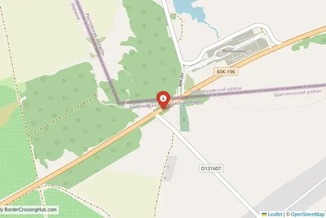
This checkpoint connected Ukraine's Luhansk Oblast with Russia's Rostov Oblast. It was a smaller crossing, likely with limited hours, intended for passenger cars and local traffic. Its purpose was to serve the communities of the Stanytsia Luhanska and Millerovo raions, which had deep and long-standing cross-border ties. It allowed people to access markets, services, and relatives without making long detours to the larger, more congested crossings.
A History of a Cossack Frontier
The history of this region is that of the Don Cossacks and the historic territory of the Don Host Oblast. It has been a frontier for centuries, a land of freedom-loving Cossacks, Russian peasants, and Ukrainian settlers. The modern border is a legacy of the Soviet administrative divisions, which often cut across these historic Cossack lands. After 1991, the Krasna Talivka-Voloshinoye crossing was a key point for maintaining the deep family and economic connections that spanned this new international frontier. It was a place where the shared Cossack heritage was more palpable than the political division of the border.
Nearby Border Crossings
Former Border Procedure
The border crossing procedure, when it was operational, was a standard two-part process. Travelers would first complete exit formalities at the Ukrainian checkpoint at Krasna Talivka. They would then proceed to the Russian entry checkpoint at Voloshinoye for a full inspection by the Russian Border Guard Service and Federal Customs Service. A valid passport and, if required, a Russian visa were necessary. As a smaller, local crossing, the process was generally less formal and faster than at the main highways, serving a community that was familiar to the guards on both sides.
The Surrounding Region
The surrounding area is a rural landscape of rolling steppe and fertile black earth. On the Ukrainian side, Krasna Talivka is a small village in the Stanytsia Luhanska Raion, an area that became a major frontline in the war that started in 2014. The major city of Luhansk is further to the south. On the Russian side, the crossing leads into the Rostov Oblast, the heartland of the Don Cossacks. The nearest Russian town of significance is Millerovo. The entire region is dotted with villages and towns that share a common history and cultural heritage.
Closure Due to War
The closure of this crossing was one of the earliest casualties of the war in Donbas, which began in 2014. Following the Russian-backed separatist takeover of parts of the Luhansk Oblast, the Ukrainian government lost control of this section of the border. The crossing was closed by Ukrainian authorities, and the area became part of the "line of contact." Since the full-scale invasion in 2022, the entire Luhansk Oblast has been occupied by Russia, and the former international border has been effectively erased by the occupying forces, though it remains the de jure border under international law, with the situation unchanged as of early 2026.
Final Considerations
The Krasna Talivka–Voloshinoye border crossing was once a vital local link, a bridge that connected communities and families in the shared historical landscape of the Donbas. It was a place of everyday commerce and human interaction. Its closure in 2014 was a harbinger of the larger conflict to come. Today, it is deep within occupied territory, a silent testament to the long and tragic war that has devastated the region. Its story is a powerful reminder that the current conflict did not begin in 2022, but has deep roots in the events that began to unfold on these quiet country roads a decade ago.
View all border crossings between Ukraine and RussiaPractical information
Currency
Limited exchange UAH, RUB
Safety information
Controlled security zone
Connectivity
4G
Have you crossed here?
Help other travelers by sharing your experience, wait times, and any updates.