Monthly Update (September 2026):
Clair, New Brunswick & Fort Kent, Maine Border Crossing remains an important local connection across the St. John River, with no major September disruption identified. The crossing links the two communities directly and remains open around the clock, making it particularly useful for travelers following U.S. Route 1 or New Brunswick Route 1. September traffic should generally be manageable outside local commuter periods.
About this crossing
Operational Details
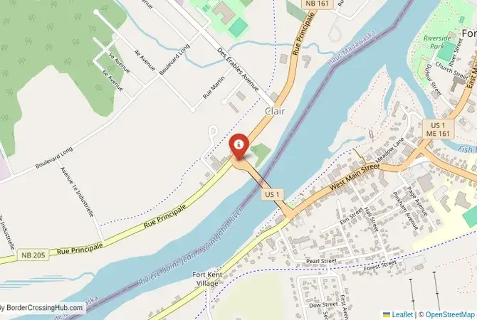
This checkpoint connects Aroostook County, Maine, with Madawaska County, New Brunswick. It is a major regional crossing, open 24/7. The Clair-Fort Kent Bridge is a modern structure that spans the St. John River, connecting the centers of the two towns. The facility is designed to handle a significant volume of local and tourist traffic, as well as freight, particularly from the region's vast timber industry. The crossing is a vital link for the local economy and for the many families that live on both sides of the river. Current wait times show no delays for passenger vehicles (as of January 2026).
A History of a Disputed Frontier
The history of this region is the history of the "Republic of Madawaska." For decades in the early 19th century, the border in this region was hotly disputed between the United States and Great Britain, leading to the undeclared, bloodless "Aroostook War." The Webster-Ashburton Treaty of 1842 finally settled the border, drawing it down the middle of the St. John River. This divided the French-speaking Acadian and Québécois communities that had settled the valley. Despite the international border, the region has maintained its unique, shared cultural identity, and French is still widely spoken on both sides of the river. The open border of today has allowed this community to function as a single, integrated region once again.
Nearby Border Crossings

Border Crossing Procedure
The border crossing procedure is a professional and efficient process. You will approach a single, primary inspection booth for the country you are entering. You will need a valid passport or other approved travel document (such as a NEXUS card or an Enhanced Driver's License). The border officer will ask you a series of questions about your citizenship, your destination, the purpose of your trip, and what goods you are bringing with you. Be prepared to declare all items. The process is generally straightforward and courteous, and the officers are accustomed to the constant flow of local, bilingual traffic. NEXUS lanes are available for expedited processing.
The Surrounding Region: United States Side
On the US side, the crossing is in the town of Fort Kent. The town is home to a historic fort from the time of the Aroostook War, a University of Maine campus, and is the starting point of the Can-Am Crown International Sled Dog Race. It is also the northern terminus of U.S. Route 1, which runs all the way to Key West, Florida. The town is a hub for exploring the vast North Maine Woods, a paradise for hunting, fishing, and snowmobiling.
The Surrounding Region: Canada Side
On the Canadian side, the crossing is in the village of Clair, New Brunswick. The region is part of the "Republic of Madawaska," and the nearby city of Edmundston is the main center of the francophone community in the province. The area is known for the New Brunswick Botanical Garden and the "Cycloparc," a paved bicycle trail that runs along a former railway line. The region is a gateway to the beautiful forests and rivers of northern New Brunswick and the neighboring province of Quebec.
Practical Travel Information
Practical planning for this route is straightforward. The main road is well-maintained. The official currencies are the US Dollar (USD) in the United States and the Canadian Dollar (CAD) in Canada. Services are available in the towns on both sides of the border. Be aware of the customs limits for goods, particularly agricultural products like potatoes, which are a major local industry. The region is bilingual, so you will hear both English and French spoken on both sides of the border. Recent traveler reports from 2025–2026 note light traffic with no major delays or restrictions beyond typical winter weather.
Final Considerations
The Fort Kent–Clair border crossing is a journey into the heart of Acadia. It is a busy, functional checkpoint that serves as a vital link for a unique and resilient bilingual community. It offers a passage through a beautiful landscape of forests and rivers and a region with a deep and fascinating history. For the traveler, it is a gateway to the vast wilderness of the North Maine Woods and the rich French-Canadian culture of New Brunswick. It is a border that is a testament to the enduring power of culture to transcend political divisions.
View all border crossings between United States and CanadaPractical information
Fuel
United States: 500 m - Canada: 500 m
Currency
Available near Fort Kent (USD, CAD)
Safety information
Generally safe, rural area
Connectivity
Wi-Fi at checkpoints, 4G
Have you crossed here?
Help other travelers by sharing your experience, wait times, and any updates.