Approximate Border Location
Wait Times
Cars 0-20m; peaks 30-150m toll days
Just crossed? Tap to report:
Operating Hours
Seasonal: 07:00 AM-08:00 PM
Crossing Types
Cars,motos,bikes; no trucks typical
Border Type
Land crossing via alpine pass road
Peak Times
09:00 AM-02:00 PM; Jul-Sep
Daily Crossings
600-3,500/day
Currency Exchange
EUR only; ATMs in Sölden/Merano
Safety Information
High-altitude pass; sudden fog/storms
Languages Spoken
Italian/German
Accessibility Features
Limited; steep grades, few ramps
About Timmelsjoch & Passeier Valley / Moos in Passeier
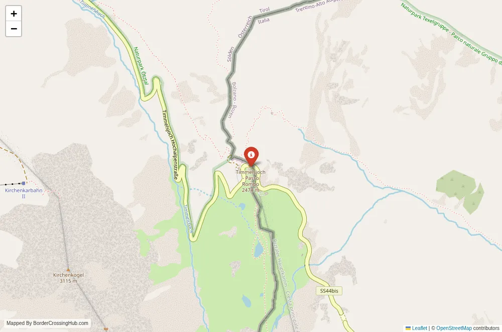
The Timmelsjoch (Italian: Passo del Rombo) places you at one of the most spectacular and best-known high Alpine crossings between Austria and Italy, linking the Ötztal valley in North Tyrol directly to the Passeier Valley (Passeiertal / Val Passiria) in South Tyrol.
Alternative Names
This point is commonly known as Timmelsjoch (German/Austrian), Passo del Rombo (Italian), Timmelsjoch Pass, or simply the Timmelsjoch border crossing. It is also frequently referred to as the Ötztal–Passeier frontier or the Hochgurgl–Moos in Passeier crossing.
Current Status and Safety Note
Austria and Italy are both in the Schengen Area, so this border has no permanent checkpoints, booths, or routine passport controls. You drive or cycle across without stopping under normal conditions. Austria continues temporary random spot checks at various Italian border points for migration and security reasons; these are selective, intelligence-based, and infrequent on this high mountain pass. Italian customs may perform occasional targeted checks, especially on commercial vehicles. The road is a true high alpine pass with steep gradients, narrow sections in places, sharp hairpins, rockfall risk, and significant elevation change. Snow, ice, and avalanches frequently close the road in winter. Always check current road status before attempting it.
Historical Background
The Timmelsjoch has been used as a shepherding and smuggling route for centuries. The modern road was constructed between 1959 and 1968 (the Italian side was completed first in 1964, the Austrian side in 1968), making it one of the newer Alpine passes open to public traffic. The pass was deliberately built as a scenic tourist route rather than a major transit artery, and it has remained free of heavy freight traffic by design. The border here was fixed after World War I when South Tyrol became part of Italy under the Treaty of Saint-Germain (1919).
Geopolitical and Economic Role
This is one of the few remaining high Alpine crossings between Austria and Italy that is open to private vehicles and tourism. It mainly serves leisure traffic: summer scenic drivers, motorcyclists, cyclists, and winter skiers/tourists heading to Hochgurgl (Austria) or the Passeier Valley ski areas (Italy). The pass connects the Ötztal (Sölden/Hochgurgl region) with St. Leonhard in Passeier and Moos in Passeier (Moso in Passiria), supporting tourism and day trips rather than commercial or commuter flows. Larger transit and freight use the Brenner Pass or the Reschen Pass.
Visa Requirements for Foreign Visitors
Schengen rules apply equally to Austria and Italy. If your nationality qualifies for visa-free entry, you cross with just a valid passport or national ID. Most non-EU visitors receive 90 days in any 180-day period across the area. Carry your travel document at all times, as random Austrian spot checks can occur anywhere in the border zone.
Crossing Procedures Step by Step
By car or motorbike, follow the Timmelsjochstraße (B186) from Sölden or Hochgurgl (Austria) up to the pass summit. You pass through the Hochgurgl ski area and toll station (toll payable in both directions), reach the highest point (marked by a large parking area, panoramic viewpoint, and Timmelsjoch Museum), and continue down the Italian side on the SS44 toward Moso in Passiria / St. Leonhard without any stop, barrier, or booth. The border is unmarked except for a simple stone marker and the change in road signs/language. Pedestrians and cyclists use the same road (no separate path exists). No forms or officials are present routinely. The reverse direction follows the identical seamless pattern.
Typical Wait Times and Peak Periods
Wait times are zero most days. You cross instantly. During peak summer (July–August) and winter ski season (December–March), traffic can build up at the toll stations and summit parking areas, but there are no queues at the border itself. Motorcyclists and cyclists are especially numerous in summer. Random spot checks add only brief pauses if they occur.
Operating Hours
The road is open 24 hours a day when not closed by weather. In practice the pass is usually open from late May / early June to early November (exact dates vary year to year; toll booths operate during daylight hours in the open season). Winter closure is normal due to heavy snow and avalanche risk; no winter maintenance occurs on the summit section.
Transportation Options to and From the Border
Drive the B186 from Sölden/Hochgurgl (Austria) or the SS44 from St. Leonhard / Moso in Passiria (Italy). No public buses cross the pass itself; local buses serve Sölden and St. Leonhard but end well before the summit. Cycling is very popular (the climb is extremely demanding from both sides, ~1,200–1,500 m elevation gain). The nearest train stations are in Ötztal Bahnhof (Austria) and St. Leonhard / Meran (Italy), both some distance from the pass.
Road Conditions and Scenery
The road is paved on both sides but narrow in places, steep, and winding with many tight hairpins. Gradients reach 10–12% on both approaches. The Austrian side passes through the Hochgurgl ski area with modern hotels and lifts. The summit area is wide and open with panoramic views. The Italian descent is steeper and more dramatic, dropping quickly into the Passeier Valley with views of the Texelgruppe mountains and the deep valley below. Scenery is outstanding: high alpine meadows, jagged Ötztal Alps peaks, distant Dolomites on clear days, alpine lakes, and vast mountain panoramas.
Seasonal Variations and Weather Impacts
Summer (June–October) provides the only reliable access for most vehicles. Winter sees heavy snow and frequent avalanche risk; the road is usually closed from November to May. Even in shoulder seasons, sudden snow, fog, or ice can make the pass dangerous. Always check road status (Austria: tirol.gv.at / anas.it or provincia.bz.it for South Tyrol) and mountain weather forecasts.
Nearby Attractions
The summit features the Timmelsjoch Experience (a small but interesting museum about the pass, alpine history, and border life) and a panoramic viewpoint. On the Austrian side, Hochgurgl and Sölden offer world-class skiing and summer mountain biking/hiking. On the Italian side, the Passeier Valley provides the Messner Mountain Museum at Schloss Juval, the historic town of St. Leonhard, and the Antholz Lake area nearby. The Ötztal and Passeier valleys both offer excellent hiking, via ferrata, and alpine scenery.
Common Scams and Warnings
No notable scams exist at this remote pass. The main risks are weather-related: sudden storms, fog reducing visibility, rockfall, and winter ice/snow. The road is narrow with limited guardrails in places. A toll is charged in both directions (payable in cash or card). Carry warm clothing, water, food, and a full tank. Do not attempt in bad weather or without checking road status.
Travel Tips and Preparation
Check real-time road conditions (Austria: tirol.gv.at/verkehr; South Tyrol: provincia.bz.it/verkehr or anas.it) and mountain weather forecasts. Bring passport/ID, warm layers, and offline maps. Pay the toll (usually €10–15 one way in recent years). Cyclists should prepare for a very strenuous climb. The pass is an out-and-back route for most; continuing far into the other country requires planning for the long descent.
Cultural and Economic Significance
This crossing connects the Ötztal region of North Tyrol with the Passeier Valley in South Tyrol, supporting tourism (especially winter sports and summer scenic driving) and local cross-border ties in a historically important Alpine transit zone.
Final Planning Advice
Confirm the pass is open and check weather/road conditions right before departure. Bring your documents, pay the toll, take the climb slowly, and savor the dramatic alpine scenery. This high mountain crossing offers one of the most beautiful and scenic ways to move between Austria and Italy. Safe travels.
No reviews yet.