Approximate Border Location
Wait Times
Cars 0-20m; peaks 30-120m timed flow
Just crossed? Tap to report:
Operating Hours
Seasonal: 07:00 AM-07:00 PM
Crossing Types
Cars,bikes; one-lane timed access
Border Type
Land crossing via alpine pass road
Peak Times
10:00 AM-03:00 PM; Jul-Sep
Daily Crossings
300-1,800/day
Currency Exchange
EUR only; ATMs in Obertilliach/Anterselva
Safety Information
High-pass weather; narrow one-lane sections
Languages Spoken
Italian/German
Accessibility Features
Limited; narrow road, few lay-bys
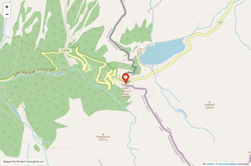
About Staller Saddle & Antholz
Staller Saddle connects Austria to Italy through one of the most scenic high mountain passes in the Dolomites, where the border lies at the summit dividing the Austrian Antholz Valley from the Italian Val Pusteria in South Tyrol.
Location and Basic Connections
You reach this crossing where the Austrian side (Staller Sattel) in East Tyrol’s Defereggen Valley meets the Italian side (Passo Stalle) in South Tyrol’s Antholz Valley. It sits at 2052 meters elevation along the L17 (Austrian) continuing as the SP46 (Italian), a narrow, winding mountain road linking the village of St. Jakob in Defereggen (Austria) to Antholz (Anterselva) in Italy. Foreign visitors cross here when traveling from Lienz or the Defereggen Valley in Austria toward Antholz, Bruneck, or the Puster Valley in South Tyrol, or the reverse for Austrian East Tyrol hiking and skiing. Alternative names include the Staller Sattel border, Passo Stalle, or Staller Saddle crossing. As a Schengen internal point, it normally allows free movement with no fixed booths, but temporary controls remain active on the Austrian side as of February 11 2026.
Historical Background and Geopolitical Role
The pass has served as a natural route across the Carnic Alps for centuries, used by local herders and traders long before modern borders. The current frontier was formalized after World War I with the 1919 Treaty of Saint-Germain, which transferred South Tyrol from Austria-Hungary to Italy. During World War II, the area saw limited action as part of the Alpine front. The road over the pass remained unpaved and seasonal until the mid-20th century, with a paved surface completed in the 1970s. It stayed open year-round only after improvements in the 1990s. Post-Schengen since 1997 (Austria) and 2007 (Italy’s full implementation), the crossing has become a popular tourist link between East Tyrol and South Tyrol, facilitating access to Antholz Lake (Lago di Anterselva), a biathlon venue, and the surrounding Dolomites. It reflects the historical division and modern reconciliation of Tyrolean culture across the Austro-Italian border.
Current Status and Safety Considerations
Austria continues temporary internal border controls with Italy until at least April 30 2026, citing persistent terrorism risks, irregular migration pressures along Mediterranean routes, organized smuggling networks, and public order concerns. Italy conducts targeted internal checks on Alpine routes until July 31 2026, focusing on migration and security. At this remote high-altitude pass, controls consist of random police stops on the Austrian side, often near the summit or descent toward St. Jakob, rather than fixed booths. Travelers report these as infrequent and brief here compared to busier crossings like Brenner or Reschenpass, with no long queues. The area has low crime typical of remote mountain passes, with no widespread scams or aggressive touts. Carry your passport or national ID at all times, especially in winter when weather can complicate travel.
Operating Hours and Wait Times
The pass road operates seasonally (typically late May to early November), with closure in winter due to heavy snow and avalanche risk; no tunnel bypass exists. Temporary controls introduce variability: most vehicles pass without stop, while a random check adds 5 to 30 minutes for document verification or questions. The crossing sees moderate tourist traffic in summer and shoulder seasons, with potential delays during peak holidays or targeted operations. Winter closure forces use of alternative routes like the Felbertauern Tunnel or Brenner Pass. Summer thunderstorms or fog can reduce visibility on the narrow, winding ascent.
Visa Requirements for Foreign Visitors
Schengen rules apply: EU/EEA/Swiss citizens travel freely with valid ID or passport. Non-EU nationals qualify for visa exemptions up to 90 days in any 180-day period if eligible, or hold a Schengen visa. The Entry/Exit System registers non-EU travelers at external borders but not routinely at internal points like this; spot checks may verify your status or documents. Present your passport during any control, plus proof of accommodation, funds, or onward travel if requested. No fees occur at this crossing.
Crossing Procedures Step by Step
You approach on the L17 from Austria or SP46 from Italy, climbing to the summit where the border lies near the small chapel and panoramic viewpoint. Normally, drive straight across as the alpine scenery continues and signs switch languages. If Austrian police conduct a control, expect a roadside pull-over near the summit for ID presentation and basic travel questions. Provide documents promptly; the process ends quickly amid mountain traffic. Pedestrians and cyclists have limited options due to the pass road’s steepness and traffic, often using parallel trails if available. The transition feels abrupt yet scenic, with immediate access to ski areas or valley descents on both sides.
Transportation Options and Road Details
No direct public transport crosses the pass: regional buses reach St. Jakob in Defereggen from Austria, and Antholz from Italy. Driving uses the narrow, winding L17/SP46, paved but steep with hairpin turns, passing through alpine meadows, forests, and rocky slopes. Scenery includes dramatic peaks, snowfields in shoulder seasons, wildflowers in summer, and distant valley views. Traffic stays moderate outside peak seasons. Cycling challenges fit riders on the steep ascent, with rewarding descents. Winter closure requires alternative routes.
Nearby Attractions and Practical Tips
The summit offers panoramic views, a small chapel, and the historic Gasthof am Staller Sattel. Antholz Valley features Lake Antholz (Lago di Anterselva), a biathlon center, and trails into the Rieserferner-Ahrn Nature Park. St. Jakob in Defereggen provides access to East Tyrol hiking and skiing. Carry ID due to controls. Euros work on both sides; cards accepted widely. Pack layers for high-altitude weather, chains in shoulder seasons if open, and water for remote stretches. Check pass status and weather forecasts seasonally. Cross in daylight for safer mountain driving and views.
Cultural and Economic Significance
The crossing sustains cross-border tourism in this Carnic Alps region, where visitors enjoy seamless access to Austrian and Italian alpine areas, hiking, and skiing. Shared Tyrolean heritage appears in local cuisine, traditions, and mountain culture. It supports local economies through winter sports and summer nature tourism, exemplifying Schengen’s high-altitude integration amid temporary security measures.
Final Planning Notes
Check official EU or national sources for updates on temporary controls, pass status, and road conditions before travel, keep ID ready, and allow extra time for weather or random checks. This scenic Alpine pass route offers a dramatic and beautiful border passage between Austria and Italy when you stay prepared.
No reviews yet.