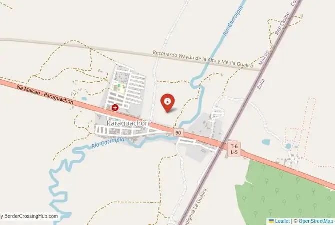
Approximate Border Location
Wait Times
30-90 min for pedestrians/vehicles
Operating Hours
Open 8:00 AM – 6:00 PM
Crossing Types
Pedestrians, vehicles
Border Type
Land crossing via road
Peak Times
Mornings (7-10 AM)
Daily Crossings
~2000 travelers/vehicles
Currency Exchange
Limited near Paraguachón (COP, VES)
Safety Information
Remote, beware wildlife
Languages Spoken
Spanish
Accessibility Features
Ramps
About Guarero & Paraguachón Border Crossing
A Crossing in the Land of the Wayuu
Important Note for Travelers: The political and economic situation in Venezuela is extremely volatile. This border crossing has been closed for long periods and is located in a region with a complex security situation. Travel to this region is not recommended. This guide is provided for historical and informational purposes only.
The border crossing connecting Paraguachón in Colombia with Guarero in Venezuela is the main northern checkpoint between the two nations. This is a journey into the heart of the Guajira Peninsula, a stunning and starkly beautiful desert landscape that is the ancestral homeland of the indigenous Wayuu people. To cross here is to travel through a land where the modern border is a relatively recent imposition on a world of ancient traditions, clan territories, and a thriving, often illicit, cross-border trade. It is a crossing defined by the harsh beauty of the desert, the resilience of the Wayuu culture, and the complex realities of a frontier that is both a formal checkpoint and a porous, informal economy.
Operational Details
This checkpoint connects the La Guajira Department of Colombia with the Zulia state of Venezuela. It is a major international crossing, and under normal circumstances, would be open 24/7. However, its operational status is often subject to the political climate. The Venezuelan government has closed the border on several occasions for long periods. The crossing is a vital artery for the limited formal trade that still exists and for the movement of people, particularly the binational Wayuu community. It is also a major corridor for the flow of Venezuelan migrants heading towards Colombia and other parts of Latin America.
Before Crossing
Crossing borders gets messy sometimes, think political flare-ups or gates shutting fast. Good travel insurance is a must for handling doctor visits, trip disruptions, or security scares. Don’t get caught unprepared. To find a policy that’s got your back, check out reliable plans today for peace of mind.
A History of the Wayuu Homeland
The history of this region is the history of the Wayuu people, a large and resilient indigenous group with a strong matrilineal culture. For centuries, they have moved freely across the Guajira Peninsula, their territory long predating the modern states of Colombia and Venezuela. The border, established in the 19th century, divided their ancestral lands. The Wayuu, however, have largely ignored the border in their daily lives, and the region is known for a massive informal economy based on the smuggling of cheap, subsidized Venezuelan gasoline and other goods into Colombia. This informal trade is a fundamental part of the regional economy and a constant challenge for the authorities on both sides.
The Border Crossing Procedure
The border crossing procedure is chaotic and subject to constant change. When the border is open, there are formal immigration and customs offices on both sides. However, the area is also known for its hundreds of illegal crossing points (`trochas`), which are controlled by armed criminal groups and are extremely dangerous. For those crossing legally, the process involves a standard two-part check. You will need a valid passport and any required visas. The atmosphere can be tense and chaotic, with a huge amount of informal activity happening all around the official checkpoint.
The Surrounding Region: Colombia Side
On the Colombian side, the crossing is near the bustling commercial city of Maicao, which is the main hub for the cross-border trade. The capital of the department is Riohacha. The Guajira Peninsula is a stunning destination for adventurous tourism, known for its dramatic desert landscapes that meet the turquoise Caribbean Sea at places like Cabo de la Vela and Punta Gallinas, the northernmost point of South America. It is a region of incredible beauty but also of extreme poverty and complex social challenges.
The Surrounding Region: Venezuela Side
On the Venezuelan side, the crossing is the gateway to the state of Zulia and the major city of Maracaibo, the center of Venezuela’s oil industry. The region is known for the Catatumbo lightning, a unique atmospheric phenomenon of constant, silent lightning. However, the security situation in Zulia is extremely precarious, and the region has been severely affected by the economic collapse, with major failures in the electricity and water supply. Travel in this region is extremely dangerous.
Practical Travel Information
Travel to this region is strongly discouraged. The security situation is extremely precarious, with the presence of numerous armed groups. The official currencies are the Colombian Peso (COP) in Colombia and the Venezuelan Bolívar (VES) in Venezuela. Any travel must be undertaken with extreme caution and a deep understanding of the risks involved. The Wayuu people often do not recognize the authority of either state, and the region operates under its own complex set of rules.
Final Considerations
The Paraguachón–Guarero border crossing is a journey into a unique and complex world. It is a place where a modern international border is superimposed on an ancient indigenous territory, and where formal state control is constantly challenged by informal economies and traditional ways of life. It is a symbol of the Venezuelan crisis and the resilience of the Wayuu people. It is a beautiful, dangerous, and unforgettable frontier, a true borderland in every sense of the word.
No reviews yet.
