Approximate Border Location
Wait Times
0-5m; occasional checks 10-30m
Just crossed? Tap to report:
Operating Hours
Open 24 hrs (12:00 AM-11:59 PM)
Crossing Types
Ped,bikes only; trail
Border Type
Land crossing via pedestrian trail
Peak Times
10:00 AM-04:00 PM; weekends
Daily Crossings
40-300/day
Currency Exchange
EUR; DKK in nearby towns; ATMs
Safety Information
Remote trail; limited lighting
Languages Spoken
German/Danish
Accessibility Features
Rough ground; no accessibility features
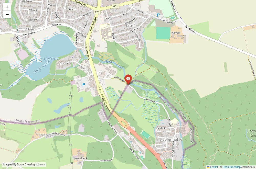
About Madeskovvej & Walking path crossing
The Madeskovvej walking path crossing provides a simple, unmarked step across the Denmark-Germany border along a quiet trail in the rolling countryside near Flensburg.
Current Status and Safety Note
As of February 2026, this remains an open Schengen internal border with no permanent checks. Denmark keeps temporary spot controls at land crossings due to security matters like organized crime and migration risks. Random police stops for ID checks can occur when entering Denmark, though this pedestrian-only path sees them infrequently. The spot itself carries minimal risk; no significant scams or issues get reported here. Bring your passport or national ID card regardless, as Danish authorities may request it. Verify latest updates through Danish police announcements or your home country’s travel advisory before going.
Alternative Names
It appears as Madeskovvej (Danish side) to Teichweg (German side), or simply the Madeskovvej path crossing. Some lists include it under pedestrian or cycle-only crossings.
Location and Basic Connection
This crossing sits in a rural area south of Kruså in Denmark and north of Flensburg in Germany, specifically near Zollsiedlung in Harrislee municipality. A narrow walking path connects Madeskovvej on the Danish end to Teichweg on the German side, crossing over a small bridge or culvert roughly 12-15 meters long. The path serves pedestrians and cyclists exclusively; vehicles stay prohibited except perhaps for rare local access with special permission. It ranks among the approved foot and cycle crossings along the 68 km land border, positioned somewhat centrally but away from major roads.
Historical Background
The border line here stems from the 1920 Schleswig plebiscites after World War I, when northern Schleswig opted to join Denmark following votes that adjusted the frontier based on local wishes. The area belonged to the old Duchy of Schleswig, contested between Danish and German powers for centuries. Post-1920, minor paths like this one allowed limited local movement before full Schengen openness in 2001 erased routine barriers. A small bridge at the crossing, Danish-owned, has stood since the border’s modern establishment, though its exact origins remain obscure in records.
Geopolitical and Economic Role
Within Schengen, this path handles negligible formal traffic or trade. Locals might use it for short walks, errands, or connecting to nearby trails. The broader border supports everyday cross-border life, like shopping in Flensburg from Danish towns or vice versa, but this spot contributes little economically. The wild boar fence installed along parts of the frontier avoids this area or integrates discreetly.
Practical Crossing Procedures
No infrastructure marks the spot beyond the path itself. You walk or push your bike along the trail from Denmark, cross the short bridge where the border runs, and continue into Germany without stops or signs in normal times. The line falls roughly in the middle of the bridge. Spot checks remain possible but uncommon here; if Danish police appear (more likely nearby on roads), expect quick ID verification. Schengen rules apply: valid documents for non-EEA travelers. The crossing stays available around the clock with no gates or hours.
Transportation Options
Access comes on foot or by bike via local paths from Kruså or Pattburg in Denmark, or from Harrislee/Flensburg outskirts in Germany. No public transport drops directly at the path; take buses or trains to nearby towns like Kruså or Flensburg, then walk or cycle the remaining distance. The flat landscape makes biking straightforward. Taxis or rideshares work to trailheads but not right to the crossing.
Road Conditions and Scenery
The path consists of a narrow, paved or gravel trail through open fields and gentle countryside. The short bridge crosses a drainage feature or small watercourse. Surroundings include farmland, scattered trees, and distant views toward Flensburg Fjord to the east. Quiet prevails, with occasional farm sounds or birds. In wet weather, sections can turn muddy; dry periods keep it firm.
Scams and Warnings
This remote trail draws no known scams or touts. No fake officials or extra fees appear. The primary concern involves occasional police stops during Danish controls, though they stay routine. Watch footing on the bridge if slippery from rain or leaves.
Nearby Attractions
The path ties into regional walking routes, with connections to longer trails in the area. Flensburg lies close on the German side, offering its historic harbor, old town, and museums. Kruså provides small-town Danish charm. The wider border region includes sites tied to 1920 history, like border stones or old patrol paths.
Seasonal Variations and Weather
Summer draws more walkers with pleasant temperatures and extended daylight. Autumn adds color to fields and trees. Winter brings cold winds and shorter days; ice or snow can affect the path. Spring offers fresh growth but possible mud after thaw. Rain soaks the trail periodically year-round.
Travel Tips and Preparation
Pack ID, water, and suitable shoes for potential damp sections. Use offline maps for rural paths where signal weakens. Cross in daylight for visibility and enjoyment. Combine with nearby hikes for a fuller experience. Respect farmland by staying on the designated path.
Wrapping Up Your Plans
This understated path crossing lets you experience the Denmark-Germany border in its simplest form. Check for any spot control news first, step lightly across the bridge, and take in the calm rural shift between the two countries.
No reviews yet.