Approximate Border Location
Wait Times
Usually 0-20m; delays if checks occur
Just crossed? Tap to report:
Operating Hours
08:00 AM-05:00 PM
Crossing Types
Local access; not fully staffed for int’l
Border Type
Land crossing via road bridge
Peak Times
Daytime only; weekends vary
Daily Crossings
30-200/day
Currency Exchange
MXN; BZD in Orange Walk/Chetumal; cash
Safety Information
Remote; limited policing; use main port if unsure
Languages Spoken
English/Spanish
Accessibility Features
Minimal; unpaved approaches
About La Unión & Blue Creek
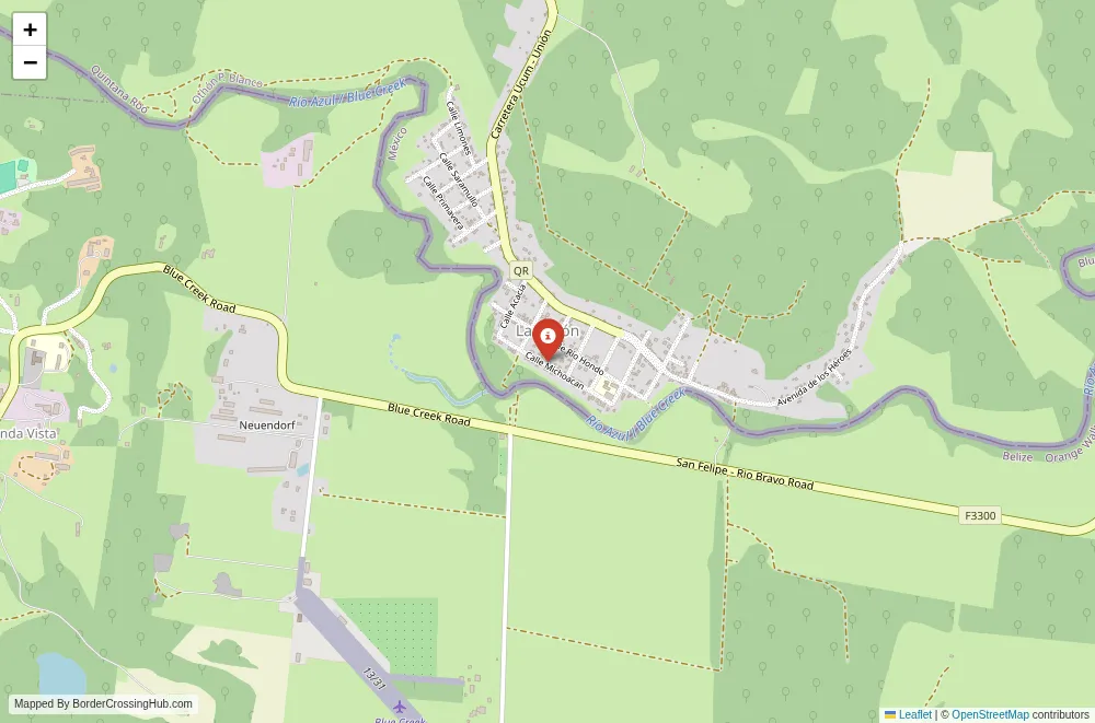
The La Unión Blue Creek border crossing spans the Río Hondo in a remote corner of the Mexico Belize frontier, linking the small Mexican settlement of La Unión in Quintana Roo state to Blue Creek Village in Belize’s Orange Walk District, one of the lesser known passages along this riverine boundary.
Location and Basic Connections
You reach this point far from major highways, about 50 km southwest of Chetumal in Mexico and roughly 55 km from Orange Walk town in Belize. La Unión sits on the northern bank of the Río Hondo, with Blue Creek Village on the southern side amid Mennonite farmlands. Access from Mexico comes via unpaved roads from the Chetumal area or nearby communities, while Belize side connects through local tracks from Blue Creek or Orange Walk. No paved international bridge exists yet, despite long standing plans; crossings rely on small rowing boats or informal wading when water levels allow. Local taxis, shared rides, or private vehicles get you close, but the final stretch often involves walking or boat hire. This route sees mainly local Mennonites, farmers, and residents rather than foreign tourists, who prefer the main Subteniente López Santa Elena bridge near Chetumal.
Alternative Names
This crossing is known as La Unión Blue Creek, Paso La Unión Blue Creek, Río Hondo crossing at La Unión, or simply the Blue Creek La Unión frontier point.
Historical Background
The Río Hondo has marked the Mexico Belize boundary since 19th century treaties following independence and colonial logwood agreements. La Unión developed as a modest riverside settlement in Quintana Roo, while Blue Creek grew from Mennonite families migrating from Mexico in the 1950s to establish agricultural colonies. The area stayed informal for decades, with locals crossing freely for trade or family visits. A 2007 meteorite impact near La Unión drew brief scientific attention but no border changes. Plans for a permanent bridge have circulated for years, yet the crossing remains rudimentary, relying on boats or low water fords, as documented in recent visits during 2024 expeditions.
Geopolitical Significance
This secondary passage complements the main Subteniente López Santa Elena bridge, serving as a local lifeline for Mennonite communities and riverine trade in produce or goods. It highlights the porous nature of parts of the 250 km Río Hondo border, with informal use common among residents. The zone lies in a triple frontier area near Guatemala, raising occasional security notes from smuggling or migration flows, though it stays quiet compared to urban points. As of early 2026, no major closures or changes affect this crossing, but it lacks full official staffing for international travelers, limiting its practicality.
Practical Crossing Procedures
You handle informal or minimal formalities here. From Mexico, walk or boat to the Belizean bank, where Blue Creek immigration may stamp passports casually or not at all for short local visits. Return trips follow the reverse. No dedicated booths exist on both sides simultaneously; some travelers report no stamps needed for quick hops, while others get basic records. Most nationalities enter Belize visa free for tourism (up to 30 days initially, extendable). Bring your passport and cash for boat fees (around 1 BZD per person). Vehicles do not cross reliably without a bridge; pedestrians or light loads dominate. The river depth varies seasonally, sometimes neck deep, preventing wading.
Typical Wait Times and Operating Hours
No fixed hours apply due to its unofficial status; crossings occur during daylight when boat operators are available or water permits. Waits depend on hailing a rower, often minutes to half an hour. Flooding closes it entirely, as seen after heavy rains. Processing, when it happens, takes under 15 minutes per side due to low oversight.
Transportation Options
From Chetumal or Orange Walk, buses reach nearby towns, then taxis or shared rides head to the riverbank. Local Mennonites use private vehicles or boats. Boat hire costs little for the short trip. The lack of a bridge keeps this point isolated; most foreigners opt for the Chetumal Santa Elena bridge with its road access.
Road Conditions and Scenery
Unpaved dirt tracks lead to both sides through flat, tropical lowlands with scrub, farms, and Mennonite fields. The Río Hondo offers wide, muddy waters lined by mangroves and jungle. Scenery shifts from open farmland to river views, with occasional wildlife like birds or crocodiles. Rain turns paths muddy; dry season exposes shallow fords.
Scams and Warnings
This unofficial crossing has minimal touts but carries risks from its informality. Some report lax stamping leading to issues later; get proper entry at staffed points if traveling deeper. The area has occasional smuggling concerns or weak border links noted by authorities. River currents and flooding pose hazards; avoid if water is high. No major crime reports target travelers here, but stick to daylight and known paths. Confirm conditions via recent traveler accounts or local contacts, as flooding or low water changes usability.
Nearby Attractions
Blue Creek Village features Mennonite farms, cheese production, and quiet rural life with a distinct community feel. La Unión provides basic stores and a glimpse of Mexican frontier towns. Nearby cenotes or trails offer nature spots. For bigger draws, head to Chetumal for markets or Orange Walk for Lamanai ruins and river tours.
Seasonal Variations and Delays
Dry season (February to May) lowers the river, enabling easier fords or wading. Wet months (June to January) raise levels, forcing boats or closing the point temporarily. Heat and humidity persist year round; flooding causes major disruptions.
Cultural and Economic Role
The crossing maintains ties between Mennonite colonies and Mexican communities, with trade in dairy, produce, and everyday items. Informal exchanges blend cultures in this riverine zone. It supports local livelihoods amid the broader Belize Mexico frontier dynamics.
Final Planning Notes
This suits adventurous locals or overlanders comfortable with informal setups; foreigners should use the main bridge for reliable stamping. Carry passport, small cash (MXN, BZD), water, and insect repellent. Check river levels and recent reports before attempting. Prepare for basic conditions and potential walking or boating.
Crossing This Río Hondo Passage
La Unión Blue Creek offers a raw, unofficial slice of the Mexico Belize frontier along the Río Hondo, rooted in local needs and Mennonite life. With caution around its informal nature and weather dependencies, you experience a genuine remote border spot far from standard tourist routes.
No reviews yet.