Monthly Update (October 2026):
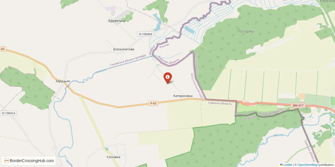
The Katerynivka & Krupets Border Crossing remains unavailable for normal international travel in October. The crossing lies on the Ukraine-Russia frontier in an area directly affected by the continuing war, and there has been no indication of a return to ordinary passenger traffic. It should therefore be treated as an inactive route rather than a usable border alternative.
About this crossing
Operational Details
This checkpoint connected Ukraine's Sumy Oblast with Russia's Kursk Oblast. It was a smaller crossing, and while it may have been designated as international, its traffic was overwhelmingly local and regional. It was located on a secondary road connecting the Ukrainian town of Hlukhiv with the Russian town of Rylsk. It was an important route for local trade, particularly in agricultural products, and for people visiting relatives or accessing services in the larger towns on either side.
A History of a Shared Heartland
The history of this region is that of the historic territory of Sloboda Ukraine and the lands of the Russian state. It has been a borderland for centuries, a place where Ukrainian and Russian cultures have long intermingled. The modern border is a legacy of the Soviet administrative divisions between the Ukrainian SSR and the Russian SFSR, often drawn with little regard for the patterns of local life. After 1991, the Katerynivka-Krupets crossing became an important point for maintaining the human connections that had been taken for granted for generations. It was a place that helped to soften the impact of the new international frontier.
Nearby Border Crossings
Former Border Procedure
The border crossing procedure, when it was operational, was a standard two-part process. Travelers would first complete exit formalities at the Ukrainian checkpoint at Katerynivka. This involved checks by the State Border Guard Service of Ukraine and customs officials. They would then proceed to the Russian entry checkpoint at Krupets for a full inspection by the Russian Border Guard Service and Federal Customs Service. A valid passport and, if required, a Russian visa were necessary. As a smaller crossing, the process was generally faster than at the main highways, but it was still a formal international border with full controls.
The Surrounding Region
The surrounding area is a rural landscape of rolling hills and fertile black earth, the heart of the agricultural regions of both countries. On the Ukrainian side, the crossing is near the ancient town of Hlukhiv, a former capital of the Cossack Hetmanate and a place of great historical significance. On the Russian side, the crossing leads into the Kursk Oblast, a region famous for the Battle of Kursk in 1943, the largest tank battle in history. The nearby Russian town of Rylsk is one of the oldest towns in the region. The entire area is dotted with villages and towns that share a common history and cultural heritage.
Closure Due to War
The closure of this crossing was an immediate and direct consequence of the full-scale Russian invasion of Ukraine in February 2022. The Sumy region, where the crossing is located, was a primary target of the invasion and saw intense fighting and a heroic defense by Ukrainian forces. The border was immediately sealed by Ukraine and has become a heavily fortified and active frontline. The checkpoint facilities have likely been damaged or destroyed in the conflict, with no reopening as of early 2026.
Final Considerations
The Katerynivka–Krupets border crossing was once a vital local link, a bridge that connected communities and families in a shared historical landscape. It was a place of everyday commerce and human interaction. Today, it is a silent and dangerous point on a closed and hostile frontier. Its story is a tragic example of how war devastates not only the grand strategic corridors but also the small, local arteries that are the lifeblood of a region. The quiet country road that once brought neighbors together now stands as a stark symbol of a brutal and tragic separation.
View all border crossings between Ukraine and RussiaPractical information
Currency
Local exchange UAH, RUB
Safety information
Security presence noted
Connectivity
4G mobile coverage
Have you crossed here?
Help other travelers by sharing your experience, wait times, and any updates.