Monthly Update (September 2026):
Izpegi Pass & Erratzu remains a quiet western Pyrenean crossing, with no significant September closure identified. The pass is open around the clock when weather permits, and its narrow mountain roads remain the main practical consideration rather than border formalities. BCH currently puts normal car waits at 0–15 minutes, with longer peaks mainly associated with summer weekends.
About this crossing
Location and Basic Connections
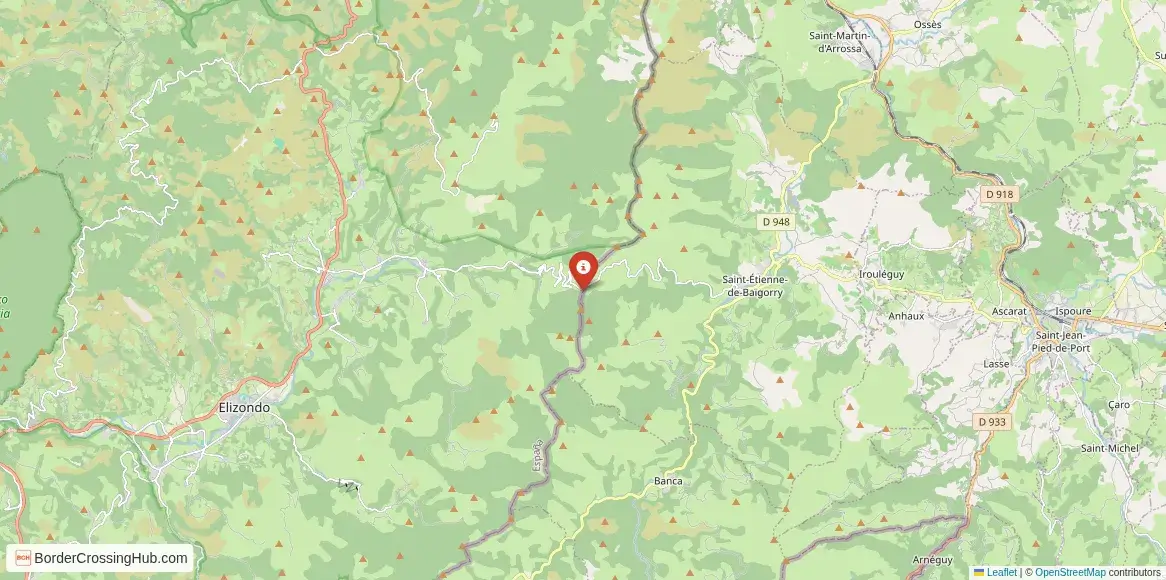
You reach this pass along narrow, winding local roads: the D949/D15 from Saint-Étienne-de-Baïgorry on the French side or the NA-2600 from Erratzu on the Spanish side. The summit lies right on the border, with the road transitioning from one country to the other in a forested clearing. Saint-Étienne-de-Baïgorry sits in the Baigorri valley, about 20 km south of Saint-Jean-Pied-de-Port, while Erratzu lies in the Baztan valley, roughly 15 km from Elizondo. The route attracts cyclists chasing challenging climbs, hikers on GR trails, and drivers seeking quiet Pyrenean scenery rather than heavy traffic. No major highways serve it; access relies on secondary roads. Local buses from Saint-Jean-Pied-de-Port or Elizondo get you to the valley bases, but the final ascent requires private vehicles, taxis, or bikes.
Alternative Names
This point is called Col d'Izpegi, Puerto de Izpegui, Coll d'Izpegi, Col d'Ispeguy, or the Erratzu Saint-Étienne-de-Baïgorry border pass.
Nearby Border Crossings

Historical Background
The pass follows ancient shepherd trails across the Pyrenees, used for centuries by Basque communities on both sides. It gained historical weight during the Spanish Civil War's 1939 Retirada, when refugees crossed similar western Pyrenean paths into France. The border line here stems from the 1659 Treaty of the Pyrenees and later agreements that shaped the Navarre-Lower Navarre frontier. The road saw gradual improvements for local use and tourism, with the summit offering views that highlight the natural divide between Baztan and Baigorri valleys.
Geopolitical Significance
As a Schengen internal border, Col d'Izpegi has no permanent controls or booths; France and Spain allow free movement for most travelers. France's temporary internal Schengen checks (extended to at least April 30, 2026, for security reasons like terrorism threats and migration) apply across borders including Spain, but secondary rural passes like this see infrequent spot patrols or none at all. The crossing supports local tourism, cycling routes, and cross-border hiking without major disruptions reported in early 2026. It remains open year-round for vehicles and pedestrians when weather permits, with no widespread closures noted beyond occasional winter snow.
Practical Crossing Procedures
You drive, cycle, or walk straight over the summit without stopping in normal Schengen conditions. The border is marked by a small pillar, stones carved with "F" (France) and "E" (España), or simple signs amid the trees. Random police or customs patrols may request ID, check vehicles, or inspect goods, but these are rare here. Most nationalities cross freely (90 days visa-free short stay in Schengen). Carry your passport or national ID for any verification. Vehicles need registration and insurance. Customs limits apply for alcohol, tobacco, or other items; declare excesses. No pedestrian or bike restrictions exist, though the road is narrow and winding.
Typical Wait Times and Operating Hours
The pass operates 24/7 when open, with no formal hours or queues. Random checks, if they occur, last minutes. Winter weather may cause short closures from snow or ice, but the low elevation keeps it more accessible than higher cols. No structured delays apply beyond seasonal conditions.
Transportation Options
Private cars or motorcycles handle the steep, remote climb best. Regional buses reach Saint-Étienne-de-Baïgorry (France) or Elizondo/Erratzu (Spain), then taxis or rideshares cover the rest. Cycling is popular for the challenging gradients (average 6-7%, with steeper pitches up to 12% on the French side). No direct public transport crosses routinely. The route suits independent travelers or those linking French Basque valleys to Navarre.
Road Conditions and Scenery
The French ascent from Saint-Étienne-de-Baïgorry features consistent climbs through forests and pastures, while the Spanish descent to Erratzu feels more gradual but winding. Roads stay narrow with tight curves and exposure in places. Scenery includes lush green valleys, oak woods, mountain streams, and open summit views of the surrounding peaks. Winter requires chains; summer brings clear roads but potential heat or rockfall.
Scams & Warnings
This quiet mountain pass sees almost no scams or touts. Narrow roads demand caution with oncoming traffic, cyclists, or livestock. Poor weather can slow or briefly close access; check forecasts. Random ID checks may occur; cooperate fully. The area has low crime against visitors but high altitude and curves pose driving risks. Carry supplies for potential waits or minor weather issues.
Nearby Attractions
Saint-Étienne-de-Baïgorry offers Basque village charm with churches, pelota courts, and access to the Aldudes valley. Erratzu provides rural Navarre life and trails into the Baztan region. The pass ties into hiking loops like Col d'Izpegi to Hautza or GR paths. Nearby Saint-Jean-Pied-de-Port serves as a Camino de Santiago start point, while the area excels for cycling cols or exploring Basque culture.
Seasonal Variations and Delays
Winter risks snow and ice on approaches, with occasional short closures or chain needs. Summer offers reliable access and peak cycling/hiking traffic. No major seasonal shutdowns beyond weather.
Cultural and Economic Role
The pass sustains ties between Baigorri and Baztan communities, boosting tourism and local trade. It blends Basque traditions across the border in food, language, festivals, and mountain life.
Final Planning Notes
Carry ID for any spot checks, check weather/road status via local sources or apps, and prepare for steep, narrow driving. This suits cyclists or drivers comfortable with scenic mountain routes.
Crossing This Low Western Pyrenean Pass
Col d'Izpegi Izpegi Pass gives you a peaceful, forested border hop in the western Pyrenees, where Basque valleys meet with minimal formalities. With weather awareness and standard prep, you enjoy this quiet frontier link between France and Spain.
View all border crossings between France and SpainPractical information
Fuel
France: 8 km - Spain: 12 km
Currency
EUR only; ATMs in Saint-Étienne/Baztan
Safety information
Fog/snow risk; occasional police presence
Connectivity
Wi-Fi points; 4G
Have you crossed here?
Help other travelers by sharing your experience, wait times, and any updates.