Monthly Update (September 2026):
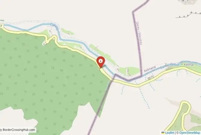
Cijevna Zarijebačka & Grabom remains a small Albania-Montenegro road crossing, with no significant September closure identified. Montenegro officially classifies Grabom-Cijevna Zarijebačka as a passenger road crossing, although it is much less important than Božaj-Hani i Hotit or Sukobin-Muriqan. Its location in the mountainous border area means the approach roads are more relevant to travelers than queue times. There is no new September restriction affecting ordinary passenger traffic.
About this crossing
Operational Details
This checkpoint connects the Malësi e Madhe region of Albania with the Podgorica Capital City municipality of Montenegro. It is a smaller crossing, and while it may be designated as international, it primarily serves local traffic. It is open 24/7, though the narrow, winding mountain road can be affected by weather conditions, especially in winter when snow can make the road impassable. The road is paved but is very narrow and has many hairpin turns, requiring a cautious and confident driver. It is not suitable for large vehicles.
A History of the Highland Tribes
The history of this region is the history of the highland tribes (Malësorët) of northern Albania and southern Montenegro, such as the Kelmendi and Gruda clans. For centuries, this was a fiercely autonomous region within the Ottoman Empire, where the rugged terrain allowed the clans to maintain their own laws and traditions. The Cijevna/Cem river canyon was their heartland. The modern border, established in the early 20th century, divided these tribal territories, separating communities and families. This crossing, when open, is a vital link for these communities, allowing them to maintain the connections that have existed for centuries, long before the modern states were formed.
Nearby Border Crossings
Border Crossing Procedure
The border crossing procedure is a standard two-part process. You will first complete exit formalities at one country's checkpoint and then proceed to the other country's checkpoint for entry inspection. As neither Albania nor Montenegro is currently in the EU, you will undergo full customs and immigration checks. You will need a valid passport, vehicle registration, and international insurance (Green Card). While many nationalities can enter both countries visa-free for short stays, it is essential to check the specific requirements for your nationality in advance. As a small, local crossing, the process is usually quick and personal, with none of the queues of the main highway.
The Surrounding Region: Albania Side
On the Albanian side, the road follows the spectacular Cem River valley. This is the heart of the Malësi e Madhe region, a gateway to the Albanian Alps. The road itself is an attraction, offering breathtaking views of the canyon. The route is part of a scenic loop that connects with the main crossing at Han i Hotit. The area is dotted with traditional stone houses (kullas) and small, self-sufficient farms. It is a paradise for adventurous travelers, hikers, and those seeking to experience the traditional culture of the Albanian highlands.
The Surrounding Region: Montenegro Side
On the Montenegrin side, the road continues to follow the Cijevna River canyon, which is equally spectacular. The river has carved its way through the limestone, creating a dramatic landscape. A popular spot is the "Niagara Falls" (a local name for a series of waterfalls on a tributary), which is a beautiful place for a stop. The road leads towards the capital city, Podgorica. This route offers a much more scenic and dramatic entry to the capital than the main highway from the south.
Practical Travel Information
Practical planning is absolutely essential for this route. You must have a suitable vehicle and be comfortable with narrow, winding mountain roads. Check the weather and road conditions before you set out, especially outside of the summer months. The official currencies are the Albanian Lek (ALL) in Albania and the Euro (EUR) in Montenegro. There are no services at the border itself. You must be self-sufficient with fuel, food, and water. Ensure your vehicle's Green Card insurance explicitly covers both Albania and Montenegro.
Final Considerations
The Grabom–Cijevna Zarijebačka border crossing is a route for the adventurous traveler. It is a journey through a landscape of raw, stunning beauty and a region with a deep and proud history. It is not the fastest or the easiest way to cross the border, but it is by far the most memorable. It is a passage that connects two parts of a shared highland culture, a journey into the wild heart of the Dinaric Alps, and a testament to the enduring spirit of the people who call these mountains home.
View all border crossings between Albania and MontenegroPractical information
Fuel
Albania: 12 km - Montenegro: 18 km
Currency
Limited nearby (ALL, EUR)
Safety information
Quiet area, low incidents
Connectivity
Basic 3G coverage
Have you crossed here?
Help other travelers by sharing your experience, wait times, and any updates.