Approximate Border Location
Border Countries
- 🇧🇩Bangladesh
- 🇮🇳India
Border Cities
- 🇮🇳Dawki
- 🇧🇩Tamabil
Wait Times
30–60 min typical
Just crossed? Tap to report:
Operating Hours
Open 8:00 AM–6:00 PM
Crossing Types
Pedestrians, vehicles
Border Type
Land crossing via road
Peak Times
7:00–10:00 AM, weekends
Daily Crossings
4,000–6,000 crossings
Currency Exchange
Exchange near Tamabil (BDT, INR)
Safety Information
Safe, minor congestion
Languages Spoken
Bengali, Hindi, English
Accessibility Features
Ramps, assistance
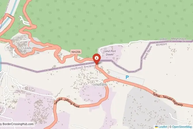
About Dawki & Tamabil
Monthly Update (March 2026):
As of 03/2026, the Dawki & Tamabil Border Crossing moves at a steady pace with cargo trucks carrying stone and construction materials between India and Bangladesh. Freight inspections can slow the truck lanes while passenger vehicles usually pass quicker. Late morning often brings the longest lines. Trade demand keeps the crossing active most days.
No Cell Service at the Border? No Problem.
Don’t get caught scrambling for paperwork when you lose signal. Download the complete Asia Transit Guide directly to your device and access every critical detail, fast-track strategy, and border rule – 100% offline.
The Tamabil-Dawki Crossing: A Scenic Himalayan Gateway
The border crossing at Tamabil in the Sylhet division of Bangladesh, which connects to the Indian town of Dawki in the state of Meghalaya, is arguably the most beautiful and dramatic land border on the entire subcontinent. This is not a crossing of dusty plains, but of lush, green mountains, deep gorges, and crystal-clear rivers. The border is marked by the Dawki Bridge, a steel suspension bridge built by the British in 1932, which spans the stunningly turquoise Umngot River. On one side are the rolling hills and tea gardens of Bangladesh; on the other, the steep, jungle-clad Khasi Hills of Meghalaya rise abruptly. This is a major tourist crossing, popular with travelers from both countries and with foreigners. The atmosphere is a mix of commerce, tourism, and breathtaking natural beauty. It is a place where the border formalities are overshadowed by the spectacular landscape, a truly memorable entry or exit point from either country.
A History of Hills, Trade, and Natural Beauty
The history of this region is that of the Khasi and Jaintia kingdoms, indigenous peoples who have inhabited these hills for centuries. The border is a British colonial construct that divided their traditional lands. The Dawki Bridge was built to facilitate the transport of coal and limestone from the hills of Meghalaya down to the plains of Bengal. This trade continues to this day, and the crossing is a major commercial point, with hundreds of trucks daily carrying stone and other minerals from India to Bangladesh. In recent years, the crossing’s fame has grown exponentially due to tourism. The Umngot River at Dawki, with its famously clear water that allows you to see the riverbed meters below, has become a major attraction. The image of colorful boats floating on what looks like a sheet of glass has become iconic. The crossing is now a destination in itself, a place where people come simply to see the bridge, the river, and the unique spectacle of two countries meeting in such a beautiful natural setting.
The Border Crossing Procedure: A Walk Across a Historic Bridge
The border is open during daylight hours. The process is generally straightforward and accustomed to tourists, but the facilities are somewhat spread out. You must have a valid visa for the country you are entering, obtained in advance.Exiting Bangladesh (Tamabil): The Bangladeshi immigration and customs offices are located in the town of Tamabil, a short distance before the actual border bridge. It is a functional, multi-story building. You will need to get your passport stamped for exit by the immigration officials and have your luggage cleared by customs. The process is usually quite smooth.The Walk to the Bridge: After clearing the Bangladeshi post, you will need to take a local CNG (auto-rickshaw) or walk about one kilometer to the border itself. This road is often congested with the massive queues of trucks waiting to cross.The Dawki Bridge: You will then walk across the historic suspension bridge. This is the no-man’s-land. The views of the Umngot River gorge from the bridge are spectacular. You will see the flotilla of tourist boats on the river below. This is the most scenic part of any border crossing in the region.Entering India (Dawki): The Indian immigration and customs office is a small building located on the side of the road immediately after you cross the bridge. You will present your passport and your Indian visa to the officer and get your entry stamp. The customs check is usually brief for tourists. Once you are cleared, you are officially in the state of Meghalaya.
Route, Onward Travel, and Meghalaya’s Wonders
On the Bangladeshi side, the nearest major city is Sylhet, which is about a 1.5 to 2-hour drive from the Tamabil border. There are regular buses and shared taxis. On the Indian side, after crossing at Dawki, you can hire a shared or private taxi for the journey up to Shillong, the capital of Meghalaya. The drive is a spectacular one, winding up through the lush, green Khasi Hills, a journey of about 3-4 hours. The road is scenic but winding. Dawki itself is a major tourist spot for boating on the river. This crossing is the perfect gateway to exploring the wonders of Meghalaya, known as the “Abode of the Clouds.” Nearby attractions include Mawlynnong, famous as “Asia’s Cleanest Village,” and Cherrapunji (Sohra), one of the wettest places on earth, with its stunning waterfalls and unique living root bridges. This border allows for a fantastic travel itinerary combining the tea gardens and shrines of Sylhet with the natural wonders of Meghalaya.
Final Planning Advice for a Scenic Gateway
The Tamabil-Dawki crossing is a highlight of any trip to the region. It is a border that is as much about the journey and the scenery as it is about the destination. The key is to have your visas sorted in advance and to be prepared for the somewhat spread-out nature of the immigration posts. Budget some extra time to enjoy the views from the bridge and perhaps even take a boat ride on the Indian side before you continue your journey. The crossing is a beautiful and relatively relaxed introduction to the unique culture and stunning landscapes of Meghalaya, making it the most highly recommended border for travelers in this part of the world.
No reviews yet.