Approximate Border Location
Wait Times
Closed/limited; delays 240-720m if open
Just crossed? Tap to report:
Operating Hours
Seasonal daylight; permit-only
Crossing Types
Permit/military; no public crossing
Border Type
Land crossing via high-altitude pass
Peak Times
Summer mornings; limited windows
Daily Crossings
0-100/day
Currency Exchange
INR; CNY not at pass; cash in Tawang
Safety Information
High-altitude; strict controls
Languages Spoken
Hindi, Chinese, English
Accessibility Features
Not accessible; steep road
About Bum La Pass & Tsona County / Tibet
Monthly Update (March 2026):
As of 03/2026, the Shipki La & Ngari / Tibet Border Crossing remains largely closed for regular travel. The high mountain pass stays quiet most of the time, with little sign of civilian traffic. Border patrol presence is more noticeable than vehicles. Seasonal weather and policy decisions continue to determine activity.
No Cell Service at the Border? No Problem.
Don’t get caught scrambling for paperwork when you lose signal. Download the complete Asia Transit Guide directly to your device and access every critical detail, fast-track strategy, and border rule – 100% offline.
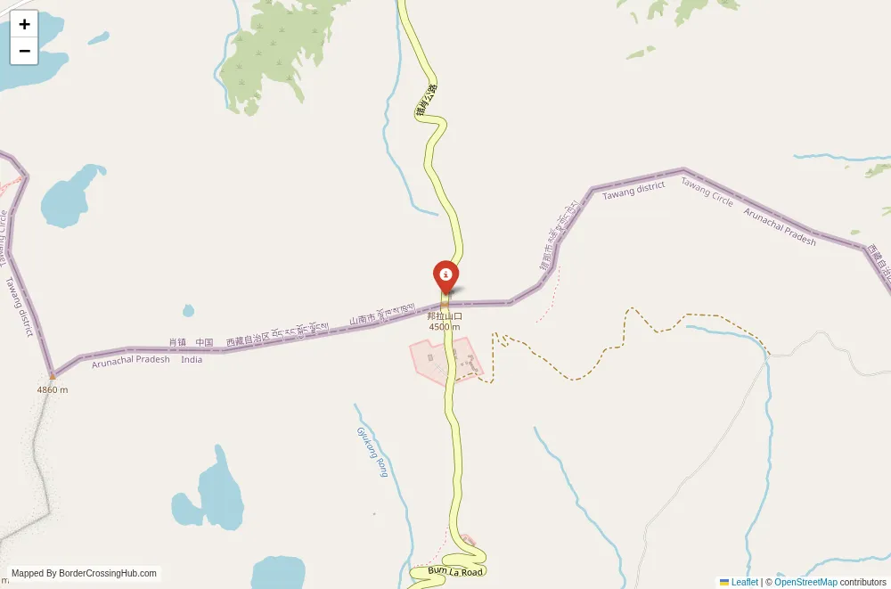
The Bum La Pass border crossing (also known as Bum La or Bumla) connects India’s Tawang district in Arunachal Pradesh to China’s Tsona County (Cona County) in the Tibet Autonomous Region. You reach this high-altitude pass when traveling the strategic Tawang region, often as part of military patrols, official delegations, or limited civilian access under strict permit systems. Situated at an elevation of 4,587 meters, Bum La serves primarily as a military and flag meeting point rather than a commercial trade route, with occasional use for controlled exchanges or symbolic interactions between Indian and Chinese forces.
Location and Connections
The pass lies along the McMahon Line, the de facto boundary in this sector, roughly 37 kilometers north of Tawang town in Arunachal Pradesh. From Tawang, the approach follows a winding, high-altitude road built and maintained by the Border Roads Organisation (BRO), passing through Sela Pass (at 4,170 meters) and Nuranang before reaching the Bum La post. On the Chinese side, it connects to Tsona (Cona) County, with roads leading toward Lhasa or other parts of southern Tibet. The terrain consists of stark, windswept plateaus, glacial lakes, and rocky ridges typical of the eastern Himalayas. No civilian trade infrastructure exists; the area features military outposts, observation posts, and basic shelters on both sides. No rail or air links serve directly; access depends on road travel under heavy security oversight.
Historical and Geopolitical Background
Bum La has long held strategic importance due to its position along one of the shortest routes from Tibet into Arunachal Pradesh. The pass gained notoriety during the 1962 Sino-Indian War, when Chinese forces advanced through it, capturing Tawang before withdrawing. Post-war, it remained a flashpoint, with both sides establishing forward posts and conducting regular flag meetings to manage incidents. The pass saw symbolic importance in 2006 when the first formal flag meeting occurred after decades, and it hosted several subsequent meetings to discuss troop disengagements or confidence-building measures. In recent years, tensions flared with the 2020 Galwan Valley clash elsewhere along the LAC, prompting India to accelerate infrastructure like all-weather roads and tunnels (including the Sela Tunnel opened in 2024). China has built extensive facilities opposite Bum La, including villages and roads under its border consolidation program. Despite periodic standoffs, the pass hosts biannual flag meetings and remains a venue for de-escalation talks. Fun fact: Bum La is home to a small Buddhist shrine maintained by Indian troops, where prayers are offered for peace, reflecting the spiritual dimension of this militarized frontier.
Current Status and Operating Hours
As of early 2026, Bum La Pass remains closed to civilian traffic and foreign visitors. Access is restricted to Indian military personnel, authorized officials, and very limited groups with special permits from the Indian Army or Ministry of Home Affairs. No trade or tourism occurs here; the crossing functions only for official flag meetings (typically held twice a year) and emergency communications. The pass operates seasonally, open from June through October when snowmelt allows road access, with daytime hours only (roughly 9:00 a.m. to 4:00 p.m. local time) due to extreme cold and wind. Winter snow closes the route completely, often from November to May. High-altitude weather brings blizzards, sub-zero temperatures even in summer, and sudden storms. Security remains tight, with both sides maintaining forward deployments and surveillance. Monitor updates through Indian Army statements, MEA advisories, or local Tawang administration, as LAC tensions or bilateral talks can alter access protocols.
Crossing Procedures Step by Step
No public crossing procedures exist due to the military-only status. Flag meetings follow a strict protocol: Indian and Chinese delegations meet at a designated point near the pass, exchange greetings, discuss issues (patrols, incidents, or de-escalation), and return without crossing. Civilians or unauthorized personnel attempting approach face immediate interception by Indian forces. For rare permitted visits (such as official tours or media under escort), Indian side clearance involves multiple layers of verification (Aadhaar, permits, security briefing), followed by escorted movement to the post. Chinese side maintains similar controls. Wait times for meetings are minimal, but any civilian presence requires days of prior approval.
Visa Requirements for Foreign Visitors
The pass offers no entry for foreigners or civilians. Arunachal Pradesh requires a Protected Area Permit (PAP) or Inner Line Permit (ILP) for Indian citizens from certain states and restricted access for foreigners. Even with permits, Bum La remains off-limits to tourists. Chinese side requires specific visas and approvals for any Tibet entry. No visa-on-arrival or independent crossing possible. Verify via MEA or Indian Home Ministry, as the area falls under strict restricted zone rules.
Transportation Options and Road Details
From Tezpur or Guwahati, fly to Tawang’s planned advanced landing ground or drive via Bhalukpong and Bomdila (12-14 hours to Tawang). From Tawang, army or BRO vehicles or escorted jeeps reach Bum La (3-4 hours on high-altitude roads with steep drops, switchbacks, and snow risks). No public transport; movement requires military escort or special permission. Roads stay challenging: narrow, prone to landslides, and closed in winter. Acclimatization mandatory to avoid altitude sickness.
Scams and Safety Warnings
No scams occur due to restricted access, but unauthorized attempts to approach lead to detention or fines. High altitude risks acute mountain sickness; carry oxygen and medications. Geopolitical tensions along the LAC require extreme caution; stray incidents or standoffs possible. Governments advise against travel near the border without authorization. Monitor news for escalations; register with authorities if permitted.
Nearby Attractions and Practical Tips
Tawang offers the famous Tawang Monastery, Madhuri Lake, and Sela Pass views. Bum La itself provides panoramic Himalayan vistas under escort. Carry warm clothing, medications, water, snacks, and power banks; facilities minimal. Follow military guidelines strictly if permitted.
Final Notes for Planning
Bum La Pass remains a military-controlled frontier with no civilian crossing. Access is limited to authorized personnel; tourism or trade opportunities do not exist here. Monitor official channels for any changes, prioritize safety, and explore Tawang’s accessible sites instead. Safe travels.
No reviews yet.