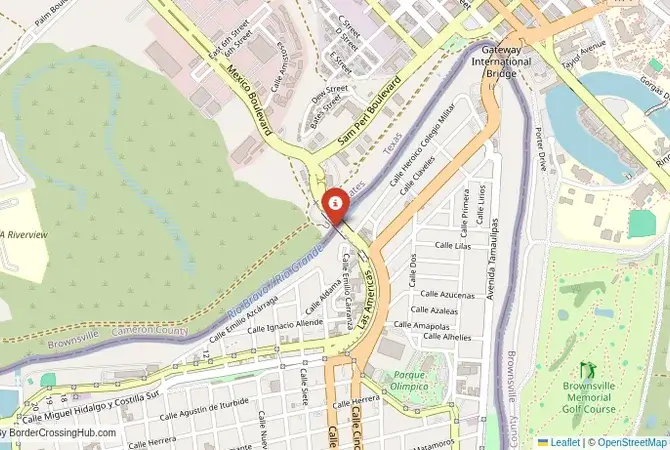
Monthly Update (September 2026):
Brownsville, Texas & Matamoros, Tamaulipas Border Crossing remains available through the Gateway/Los Indios corridor, with the Gateway bridge operating 24 hours while Los Indios has more limited hours. CBP's recent data showed the Gateway passenger crossing at around 15 minutes during one August afternoon reading, while Los Indios was showing a longer wait at the same time. No major September closure has been identified, but travelers should choose between the two ports according to their route and current wait rather than assuming the smaller crossing will always be faster.
Driving there, or sending a driver? Send them this guide.
For reports and websites
Cite this page
Border Crossing Hub (2026). Brownsville, Texas & Matamoros, Tamaulipas Border Crossing. Updated September 2026. https://bordercrossinghub.com/brownsville-texas-matamoros-tamaulipas-gateway-los-indios-border-crossing/<a href="https://bordercrossinghub.com/brownsville-texas-matamoros-tamaulipas-gateway-los-indios-border-crossing/">Brownsville, Texas & Matamoros, Tamaulipas Border Crossing (Border Crossing Hub)</a>Put this crossing's card on your website
Free. It updates on its own when our information changes.
<iframe data-bch-card src="https://bordercrossinghub.com/brownsville-texas-matamoros-tamaulipas-gateway-los-indios-border-crossing/?bch_view=card" width="100%" height="980" scrolling="no" style="border:0;max-width:480px;display:block" loading="lazy" title="Brownsville, Texas & Matamoros, Tamaulipas border crossing information"></iframe>
<p style="font-size:12px;margin:4px 0 0">Crossing information: <a href="https://bordercrossinghub.com/brownsville-texas-matamoros-tamaulipas-gateway-los-indios-border-crossing/">Border Crossing Hub</a></p>
<script src="https://bordercrossinghub.com/?bch_embed_js=1" async></script>Paste it where you want the card. The last line (a script) only adjusts the height and can be left out.
About this crossing
Historical Background
Gateway, opened in 1926, and Los Indios, in 1992, supported the Rio Grande Valley’s agriculture and Matamoros’s manufacturing. Gateway, the oldest Brownsville crossing, facilitated early citrus trade, while Los Indios eased freight congestion. During Prohibition, smugglers used the river, with a 1928 mezcal bust becoming local lore. The 2000s saw trade surge with NAFTA, and today they handle millions of crossings. Occasional disputes over produce or water rights cause delays, but their binational economic role remains strong. Recent small-scale infrastructure improvements completed in 2025 at Los Indios enhanced operations.
Crossing Details and Wait Times
Southbound, you’ll reach Matamoros’s INM office; travelers need appropriate entry documents such as passport, visa, or Forma Migratoria Múltiple (FMM) as required. Northbound, CBP requires a passport or Global Entry card. Open 24/7, vehicle waits at Gateway/Los Indios vary 0-45 minutes recently, peaking up to 1-2 hours during mornings (6–9 AM) or weekends but often lower; pedestrian lanes (Gateway only) take 15–45 minutes. Check CBP’s Border Wait Times or Mexico’s border apps for real-time updates. SENTRI lanes speed up crossings.
Nearby Border Crossings


Scams & Warnings
Scams are common in busy Matamoros, with “visa guides” charging $20–$50 for fake services. Bogus “immigration offices” may overcharge for FMM forms. Use only INM/CBP channels and apply online. Currency exchange scams near the bridges offer poor rates; carry USD/MXN cash or use Brownsville ATMs. Pickpocketing risks increase during peak hours, so secure valuables. Avoid “expedited crossing” offers. They’re scams targeting travelers in crowded conditions. Recent reports confirm these continue without significant changes.
Transportation Options
From Brownsville, it’s a 15-minute drive to Gateway via SH 4 or 20 minutes to Los Indios via FM 509. From Matamoros, Highway 2 reaches Tampico in 4 hours. Brownsville Metro buses stop near Gateway, ideal for pedestrians. Taxis and rideshares are plentiful. Confirm fares upfront. Gas and services are in Brownsville or Matamoros, 5–10 minutes away. Pedestrians use Gateway lanes; Los Indios is vehicle-only. Cyclists should use bike paths.
Road Conditions and Views
SH 4/FM 509 and Highway 2 are paved but congested during rush hours. Summer (June–August) hits 38°C, requiring AC; winter (November–March) is mild at 10–22°C. The Rio Grande and palm-lined valley offer scenic views. Check Texas’s 511 or Mexico’s (800) 990-3900 for road updates. The greenery and Matamoros’s skyline create a vibrant contrast, especially at sunset, making it a striking drive.
Local Sights
Brownsville’s Historic Battlefield Trail, 15 minutes north, explores border history. Matamoros’s Plaza de la Reforma, 10 minutes south, hosts markets and festivals. Try Brownsville’s tacos at La Mexicana or Matamoros’s carne asada at El Mesón. South Padre Island, 30 minutes east, offers beaches, while Tampico’s historic center, 4 hours south, is great for cultural exploration.
Cultural and Economic Role
This crossing blends Texas’s coastal heritage with Matamoros’s vibrant Mexican culture, seen in shared events like the Brownsville-Matamoros Sombrero Festival, featuring music and food. It supports trade in produce and electronics, fueling both economies. Brownsville’s tourism and Matamoros’s factories thrive on cross-border visitors. Community markets, rodeos, and festivals foster a strong binational bond, with locals sharing a love for spicy cuisine and traditions.
Travel Tips
Open 24/7, but check CBP/INM for holiday schedules. Carry USD/MXN for tolls ($3–$5) or duty-free shops. Appropriate entry documents save time for travelers. Summer drivers need hydration; check Texas’s 511 or Mexico’s (800) 990-3900 for road conditions. Declare all goods. Agents are strict on produce and alcohol. Secure valuables and pack snacks for variable waits.
Extra Tips for Visitors
Cell service is reliable but spotty in Matamoros’s outskirts. Download maps ahead. Summer heat is intense; winter is mild but dusty. Locals are friendly. Ask about 1930s smuggler tales for fun insights. Try Brownsville’s The Vermillion for Tex-Mex or Matamoros’s Los Norteños for gorditas. Photographers, catch sunrise over the Rio Grande for dramatic shots. This crossing’s lively energy and cultural richness make it a unique stop.
View all border crossings between United States and MexicoHeading to Brownsville, Texas & Matamoros, Tamaulipas? Take this with you.
One page with the hours, waits, emergency numbers and coordinates. Works without signal.
Practical information
Fuel
United States: 500 m - Mexico: 500 m
Currency
Limited near Brownsville (USD, MXN)
Safety information
Caution, rural crime
Connectivity
Wi-Fi at checkpoints, 4G
Have you crossed here?
Help other travelers by sharing your experience, wait times, and any updates.