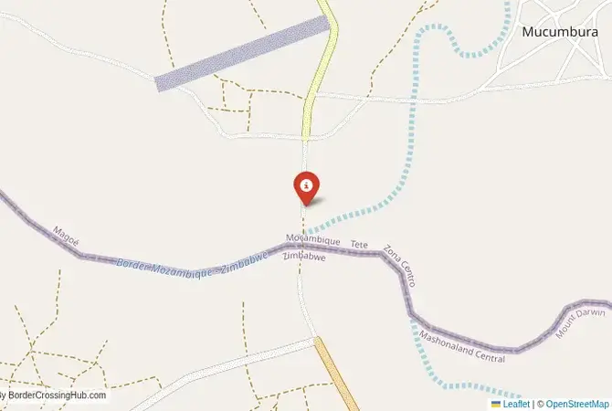
Approximate Border Location
Border Countries
- 🇲🇿Mozambique
- 🇿🇼Zimbabwe
Border Cities
- 🇲🇿Mukumbura
- 🇿🇼Musevenzo
Wait Times
30–60 min typical
Just crossed? Tap to report:
Operating Hours
Open 7:00 AM–5:00 PM
Crossing Types
Pedestrians, vehicles
Border Type
Land crossing via road
Peak Times
7:00–10:00 AM, weekends
Daily Crossings
1,900–2,100 crossings
Safety Information
Safe, remote area
Languages Spoken
Portuguese, Shona, English
Accessibility Features
Ramps, assistance
About Mukumbura & Musevenzo
Monthly Update (June 2026):
In 06/2026, Mukumbura & Musevenzo Border Crossing stays quiet compared with the larger regional gateways. Crossings are generally straightforward, although processing can take longer when several vehicles arrive at once. Recent weeks have been mostly stable, with local travel patterns creating the occasional slowdown.
Important Note: A Remote and High-Risk Border
The border crossing at Mukumbura in Mozambique, which connects to the Zimbabwean side of the border, is located in an extremely remote, underdeveloped, and historically volatile region. This is not an official international border crossing for foreign tourists. It is a minor, local post that has been frequently closed due to security concerns and a lack of infrastructure. The region has been affected by the Mozambican civil war and the Zimbabwean liberation struggle. This guide is for geographical and historical context only. It is not a viable or safe crossing for travelers.
The Mukumbura Crossing: A Zambezi Valley Frontier
The border crossing point at Mukumbura is located in the low-lying, hot, and remote Zambezi River valley. This is a wild and sparsely populated region of bushveld, baobab trees, and subsistence farming communities. The crossing is not a major highway but a simple, dusty outpost on a minor dirt road. Its significance is historical and strategic, rather than economic. It lies in a region that was a major infiltration route and operational area during the Zimbabwean War of Independence (the “Bush War”). The atmosphere is one of profound isolation and a heavy, latent sense of a difficult history. For the traveler, this is a no-go zone, a point on the map that represents one of the most remote and challenging frontiers in southern Africa, a place where the legacy of liberation wars still hangs in the air.
A History on a Liberation War Frontline
The history of this border is the history of the Zimbabwean struggle for independence. The Tete province of Mozambique, where Mukumbura is located, was a key ally of the ZANLA liberation forces (the armed wing of Robert Mugabe’s ZANU party). FRELIMO, the ruling party of Mozambique, allowed ZANLA to establish major bases in Tete, from which they launched attacks into Rhodesia (now Zimbabwe). The Mukumbura area was a major frontline in this war. The border was a constant scene of cross-border raids, battles, and “hot pursuit” operations by the Rhodesian security forces. The entire region was heavily mined and was a free-fire zone. The border crossing itself was a key strategic point for the guerillas. After Zimbabwean independence in 1980, the border was formalized, but the outbreak of the Mozambican Civil War meant that the region remained unstable and dangerous for many years. It is a border that has been defined by war and ideology, a place that was central to the political transformation of the entire region.
Signal can be a coin toss at borders, and the last thing you want is to be stuck at the gate hunting for info. We’ve pulled all our research for this region into one simple eBook that works 100% offline. It keeps everything you need in one spot so you can stay focused on the trip. Grab the guide here.
Border Procedures: Not Applicable for Tourists
As this is not an official international crossing for foreigners, there are no procedures for tourists. The crossing, when it is open at all, is designated for local traffic only with operating hours from 06:00 to 18:00.The Process for Locals: For the local residents who may be permitted to cross, the process would be a very basic one, involving checks of local identity documents by the police and military on both sides. The facilities would be minimal, likely just a simple boom gate and a small office.For a foreign traveler, there is no way to get a legal entry or exit stamp at this location. The border posts are not equipped with the necessary systems or legal authority to process international passports or visas. Any foreigner attempting to use this crossing would be in violation of the immigration laws of both countries and would be immediately detained by security forces for questioning in a very sensitive area. It is not a legal or viable route.
The Regional Context: The Zambezi Escarpment
The crossing is located in a very remote and underdeveloped region. On the Mozambican side, it is in the far north of Tete province. On the Zimbabwean side, it is in the Mashonaland Central province, at the foot of the Zambezi Escarpment. The infrastructure is almost non-existent. The roads are unpaved dirt tracks that are often impassable during the rainy season. The region is sparsely populated and has very few services. It is also a region that is still dealing with the legacy of the war, including the presence of landmines. The main international crossings between Mozambique and Zimbabwe are located much further south, on the main Beira-Harare corridor, at Nyamapanda/Machipanda and Forbes/Mutare. These are major, modern highways with full international facilities. The Mukumbura crossing exists in a different, much wilder and more challenging world.
Final Contextual Note: A Ghost of a Frontline
The Mukumbura border crossing is a place of deep historical significance for the liberation struggles of southern Africa. It is a name that evokes memories of a brutal and difficult war. However, for the modern overland traveler, it is a non-option. It is a remote, undeveloped, and insecure frontier. The story of this border is a powerful reminder of the sacrifices that were made during the fight for independence and the deep, cross-border alliances that made it possible. It is a place to be understood through history books, not to be visited. Any travel between Mozambique and Zimbabwe must be done through the main, official highway crossings to the south.
No reviews yet.